Our land 2024

Our land 2024 explores the current state of our natural assets and natural infrastructure, the benefits they provide us, and how we’ve placed them under pressure.
The report is produced jointly by the Ministry for the Environment and Stats NZ.
Our land 2024 explores the current state of our natural assets and natural infrastructure, the benefits they provide us, and how we’ve placed them under pressure.
The report is produced jointly by the Ministry for the Environment and Stats NZ.
Aotearoa New Zealand is a relatively young nation, situated on the boundary of the Pacific and Indo-Australian tectonic plates. Our geological setting gives rise to a range of dynamic landscapes, from the alpine environments of the south to the volcanic landscapes in the north. This diverse geography, and our isolation, laid the foundation for Aotearoa to become home to a wide range of ecosystems and species found nowhere else on Earth.
Over millennia these ecosystems and species have evolved, developing ways to thrive across a variety of landscapes. Human habitation has always placed additional pressure on this balance. Our pursuit of economic prosperity, founded in the rich natural resources Aotearoa has to offer, has often diminished the functioning and resilience of our natural environment – which in turn has social, economic and environmental consequences for us.
Previous reports in the Our land series have explored these pressures and their impacts (2018) and the intensity with which we’re using and managing them (2021). This report, our third in the Our land series, builds on its predecessors and explores environmental trade-offs and the potential of our natural infrastructure to provide solutions, while also seeking to take full account of the services they provide.
What the evidence in this report shows us is, when we look after our natural environment, and work within its limits, it has the capacity and resilience to provide for us as well. Examples include our wetlands, which serve as ecological hotspots while providing water filtration and mahinga kai, and our urban greenspaces which supported the mental health and wellbeing of many New Zealanders during the COVID-19 pandemic. And they include our coastal dune systems which protect coastlines during storms, and our highly productive land which underpins our agricultural and horticultural economy. The evidence shows how we’re reliant on the services that nature provides.
The choices we make today about how we manage our relationship with land are also central to improving outcomes for our freshwater and marine environments and mitigating climate change. The solutions that lie in our natural infrastructure can help us adapt to a future where we are exposed to more frequent natural hazards that pose a threat to our physical security, wellbeing, and economic prosperity.
Recognising the value that nature provides and the full range of benefits we receive from healthy, functioning ecosystems is crucial to building a safer and more prosperous future for everyone. We all have a role to play in shaping that future and we hope the evidence contained in this report helps you understand the environmental challenges and take part in the solutions.
|
James Palmer |
Mark Sowden |
We have corrected a sentence on page 26 of Our Land 2024. The sentence ‘During this same period, highly productive land became more fragmented, with an increase in small-sized parcels (2 to 8 hectares) with a dwelling, representing an increase of 64,165 hectares unavailable for farmland (see Indicator: Land fragmentation).' has been changed to ‘During this same period, highly productive land became more fragmented, with an increase in small-sized parcels (2 to 8 hectares) with a dwelling, representing an increase of 64,165 hectares (see Indicator: Land fragmentation).'.
We have corrected two typos on pages 8 and 26 of Our Land 2024. The sentence ‘Ecosystems that support flood control, such as wetlands and peatlands, but they have become increasingly important as the incidence and severity of heavy rainfall events increase with climate change.’ has been changed to ‘Ecosystems that support flood control, such as wetlands and peatlands, have become increasingly important as the incidence and severity of heavy rainfall events increase with climate change.’ on page 8.
The sentence ‘Part this is to learn the whakapapa (ancestral lineage) of the soil, and the interdependencies and interconnections between ecosystems, plants, animals and humans (Harmsworth, 2022a; Hsu et al, 2022).’ has been changed to ‘Part of this is to learn the whakapapa (ancestral lineage) of the soil, and the interdependencies and interconnections between ecosystems, plants, animals and humans (Harmsworth, 2022a; Hsu et al, 2022).’ on page 26.
We have corrected a citation on page 15 and updated the corresponding reference on page 55 of Our Land 2024. The citation and reference details for Grelet et al., 2020 have been corrected to Grelet et al., 2021.
We have corrected the links for two references on page 64 of Our Land 2024. Taura et al., 2017 and Taura et al., 2021 both have live document links.
The land and ecosystems of Aotearoa New Zealand are globally unique and nationally significant. Our connections to and relationship with the land are a defining characteristic of life in Aotearoa.
Today, all New Zealanders benefit from the many contributions land makes to our lives. Land supports our livelihoods and large parts of our economy, provides the places we are connected to, and has inherent value within ecosystems. Land is an asset and resource that our prosperity depends on, and it is also a source of meaning and value.
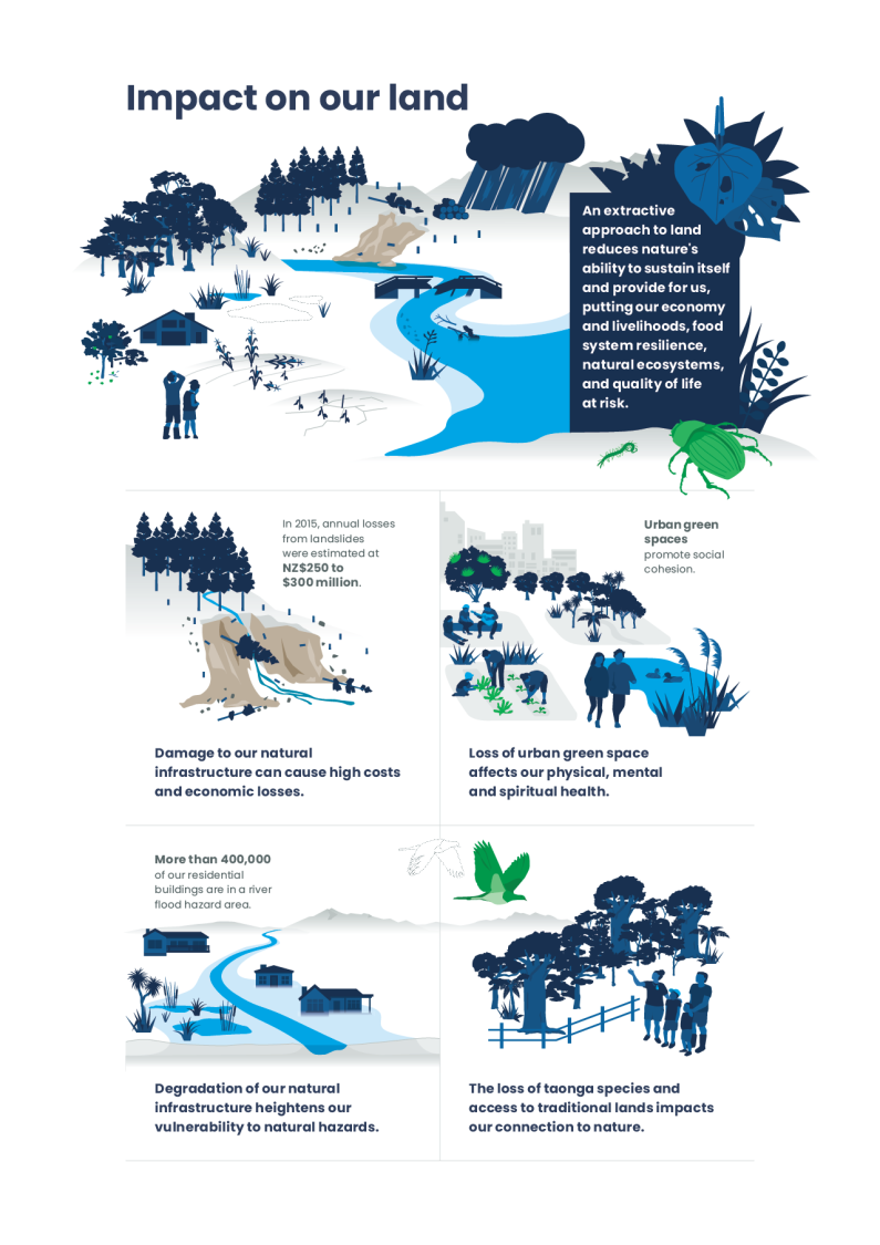
Our land 2024 describes how the ways we use the land have wide-ranging effects on our diverse ecosystems and the biodiversity they support, with cascading impacts on our economy, our resilience to disasters, and our cultural, mental and physical health.
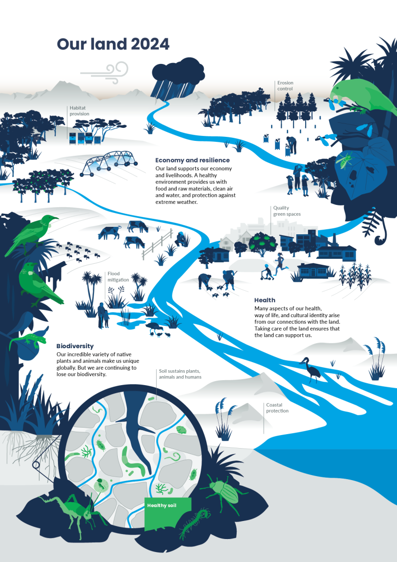
Economy and resilience: Our land supports our economy and livelihoods. A healthy environment provides us with food and raw materials, clean air and water, and protection against extreme weather.
Health: Many aspects of our health, way of life, and cultural identity arise from our connections with the land. Taking care of the land ensures that the land can support us.
Biodiversity: Our incredible variety of native plants and animals make us unique globally. But we are continuing to lose our biodiversity. Habitat provision, erosion control, quality green spaces, flood mitigation, soil sustains plant, animals and humans, coastal protection.
There are different ways of viewing nature and the multiple and complex roles it plays in our lives (IPBES, 2022). Natural processes provide us with food, clean air and water, energy, raw materials, the regulation of climate, and protection against extreme weather events. The importance of land to our economy means that it can also be viewed as an asset, supporting our lives and livelihoods.
Despite the immense value of these services, their contribution is not always reflected in traditional economic accounting (Dasgupta, 2021).
The role of land in our lives is bigger than just providing us with resources and services. Our relationship and connections with the land also support our physical, mental and emotional health, our way of life and cultural identity.
For some Māori, connection to land is through whakapapa (ancestral lineage), placing people in a special relationship as a part of ecosystems (Harmsworth, 2022a; Timoti et al, 2017). These connections are emphasised in te reo Māori (Māori language), where the word ‘whenua’ means both ‘land’ and ‘placenta’, to give nourishment and sustenance (Harmsworth & Awatere, 2013).
The Māori worldview (te ao Māori) acknowledges a natural order to the universe, which is in balance or equilibrium. When part of this system shifts, the entire system is put out of balance (Harmsworth & Awatere, 2013).
When the system is out of balance, this affects its mauri. Mauri is a te ao Māori concept that describes the spark of life (Mead, 2003) and is the binding force that holds together the physical and spiritual components of a being or thing (Durie, 1998; Morgan, 2006). An ecosystem is more able to provide benefits when its mauri is vibrant (Timoti et al, 2017).
The enormous variety of plants and animals, ecosystems, and landscapes also have their own intrinsic value, and research shows that conservation of our natural spaces is important to the majority of New Zealanders (DOC, 2011).
These different views of how we relate to our land influence our decisions over land use, the benefits of which change over time (Meyfroidt et al, 2022). For example, urban green space became even more valuable in supporting people’s physical and mental health during the COVID-19 pandemic (Davies & Sanesi, 2022). Ecosystems that support flood control, such as wetlands and peatlands, have become increasingly important as the incidence and severity of heavy rainfall events increase with climate change.
A key theme of this report is that when we look after nature, we are looking after ourselves by actively conserving the key advantages ecosystems provide. Some of these benefits are not as easily quantified as others, contributing to the reasons why they have often been systemically overlooked (Dasgupta, 2021).
One way of recognising the value of nature is to view our ecosystems and natural environment as a type of foundational natural infrastructure that supports our lives, livelihoods, health and relationships to nature.
In this report, we use the term ‘natural infrastructure’ to describe natural or semi-natural structural elements of ecosystems and landscapes that are important to delivering benefits for the environment and human wellbeing.
Examples of natural infrastructure explored here include:
Our natural infrastructure is crucial to our economy in many ways. Our primary production sectors, the basis of our export economy, depend on healthy land and soil. Aotearoa New Zealand’s tourism sector and our international brand and identity rely on our natural environment. Natural infrastructure that is in a degraded state reduces productivity and lowers our resilience to disasters, raising recovery costs in the aftermath.
Healthy, functioning natural infrastructure provides benefits to people and the wider environment. These can include improving better water quality, absorbing atmospheric carbon, enhancing flood control, supporting biodiversity and ecosystems, providing habitat, giving a sense of place and identity, and supporting our mental, cultural and physical health – among many others.
If we take care of our natural infrastructure, it can support the resilience of our society and ecosystems to environmental challenges now and into the future.
Our land 2024 is the latest in a series of environmental reports produced by the Ministry for the Environment and Stats NZ. It is the third report in the series dedicated to our land, following the 2018 and 2021 reports. It is part of the third cycle of reports released under the Environmental Reporting Act 2015.
Our land 2024 builds on previous reporting and contributes further information while we progress the fundamental changes needed to improve the reporting system in line with recommendations from the Parliamentary Commissioner for the Environment (PCE) (PCE, 2019). The primary focus is on updating recent indicators and scientific evidence about land. This report updates some of the indicators reported on in previous years and brings those indicators together with what we know from past reports and insights from the research literature.
As required by the Environmental Reporting Act 2015, we use the concepts of pressure, state and impact to report on the environment and this forms the basis for the report’s structure. The logic of the framework is that pressures can cause changes to the state of the environment, and these changes may have impacts on land and associated human (anthropogenic) values. The report also includes future outlooks throughout each section. The evaluation of specific policies is out of scope for environmental reporting releases under the Environmental Reporting Act 2015, and therefore they are not discussed here.
The data used in this report came from many sources, including Crown research institutes and central and local government. Further supporting information was provided using a ‘body of evidence’ approach. This body of evidence includes peer-reviewed, published literature, as well as mātauranga Māori (Māori knowledge) and observational tools used to identify changes in the land environment.
All data used in this report, including references to scientific literature, were corroborated, and checked for consistency with the original source. The report was produced by a team of analysts and scientists from within and outside the Ministry for the Environment and Stats NZ. It was also reviewed by a panel of independent scientists. The indicators related to our land and the date they were last updated are available on the Stats NZ indicator web pages (see Environmental indicators).
Throughout the report, we use structured analytical techniques to assess the outlook for our land, with a particular emphasis on ‘natural infrastructure’, based on international and domestic evidence. This represents a continued shift in our approach to environmental reporting. The shift is away from a focus on what has happened, towards a focus on what might happen in future, to improve public awareness of issues and support decision-making.
Unlike Our atmosphere and climate 2023, there are no commonly agreed upon scenarios specific to Aotearoa on which to base the assessments about the state and trends in Our land 2024. Therefore, to support the development of these assessments, baseline assumptions were made across a spectrum of issues.
These assumptions depict the future state that we believe to be true at the time the assessments were developed, based on the information available, and that we believe will remain true for the time period in which the assessments apply.
In making these assumptions, we have also acknowledged that other outcomes are possible. Policy initiatives, grassroots innovations, and sustainability measures could all have an impact on our future, though it can be challenging and take a long time to measure and attribute these outcomes to specific policies or innovations.
At the time of writing, there was not enough evidence to support assessments about how recent initiatives and innovations may evolve. For these reasons we have chosen to make outlook assessments for sections with a greater body of evidence supporting them, which can allow assessments to be made with a higher level of confidence.
The following key assumptions have been made for the outlook assessments in Our land 2024.
The future will always be uncertain. For this reason, the assessments should be read not as statements of fact but as descriptions of what might occur based on what we know now. To support this, we have used expressions of likelihood and confidence to help in interpretation. This methodology is aligned with other domestic agencies for consistency of language and understanding by our decision-makers. It ensures we can make assessments about current and emerging issues even when our confidence in them may be limited by the currently available evidence.
Assessments have been made only where evidence available on the past and current state of a system is sufficient to form an outlook. The assessment approach used in Our land 2024 acknowledges the need for an analytical process that can be applied across all environmental domains and knowledge systems, from science to mātauranga Māori. Importantly, the evidence and analysis produced by the international community, along with other domestic evidence and knowledge, have been incorporated into the assessments contained here.
Expressions of likelihood are underlined. Expressions of confidence, which give an indication of the reliability and level of corroboration of evidence used in an assessment, are presented in brackets at the end of each assessment (see appendix A for further explanation).
Human activities place great pressure on terrestrial ecosystems. The key pressures faced by our land environments are changes in land use, along with adverse effects from pollution, climate change, and invasive species. Pressures can stem from various underlying causes or drivers, including production and consumption patterns, human population dynamics, trade, technological innovations, and local and global governance.
Since the late 1800s, an extractive approach to land use has prevailed. This emphasises its ‘improvement potential’ for both productivity and economic purposes. Aotearoa New Zealand has witnessed the expansion of land area used for farming and commercial forestry, alongside urban intensification and ‘grey’ infrastructure growth (eg stop banks, sea walls, and roading) linked to population and consumption, and increased pollution and waste. The resulting land-use intensification has led to degradation of our soils and waters, the clearance and fragmentation of vast tracts of indigenous forest, as well as the reclamation and drainage of lakes, estuaries, wetlands, dunes, and river margins.
Our land environments continue to face these pressures. Climate change is increasingly amplifying the impact of these pressures on our natural and productive ecosystems, as observed with the increased risks due to extreme weather events and the spread of invasive species.
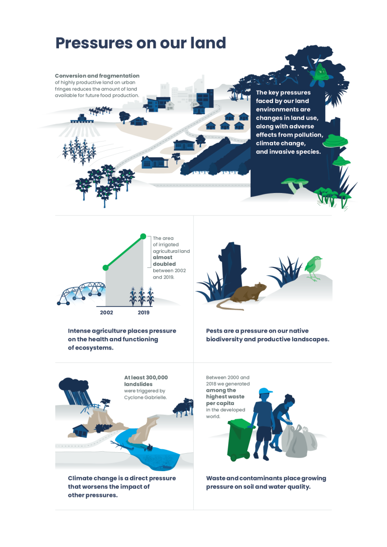
The key pressures faced by our land environments are changes in land use, along with adverse effects from pollution, climate change, and invasive species.
Intense agriculture places pressure on the health of functioning of ecosystems.
Pests are a pressure on our native biodiversity and productive landscapes.
Climate change is a direct pressure that worsens the impact of other pressures.
Waste and contaminants place growing pressure on soil and water quality.
Land that is particularly suitable for food production is classified as highly productive land (Curran-Cournane et al, 2021a). Aotearoa New Zealand’s highly productive land is vital and natural infrastructure that, due to its unique land and soil characteristics, can be used for a variety of purposes (Lynn et al, 2009). Highly productive land is often on the fringes of our cities and therefore under pressure from development and subsequent land fragmentation as cities grow outwards (Curran-Cournane et al, 2018).
Eighty-four percent of New Zealanders live in urban areas (Stats NZ, 2024b), and much of our population growth between 2018 to 2048 (likely 70 percent or more) will be in the main urban centres (Stats NZ, 2021). Our population is growing, reaching an estimated 5.3 million in September 2023, and may reach 6 million by 2050 (Stats NZ, 2020, 2024b). Around two-thirds of this growth is projected to occur in less than 3 percent of our land area, in and around Auckland, Hamilton, Tauranga, Wellington and Christchurch (Stats NZ, 2020). By 2043, a 37 percent increase in the number of households from 2018 is expected in Auckland, Hamilton and Tauranga, and around 20 percent in Wellington and Christchurch (PCE, 2023).
Population growth in Aotearoa has contributed to the expansion of our towns and cities, with the total urban area in Aotearoa growing by 15 percent between 1996 and 2018 (see Indicator: Urban land cover). In the future, demand for new housing in some cities will be met in part by building on the outskirts of urban areas, which can include highly productive land (Davis et al, 2023; PCE, 2023). For example, the Waikirikiri Selwyn district within the Ōtautahi Christchurch peri-urban zone is experiencing significant expansion of residential developments, particularly in terms of dwelling construction, which is encroaching on highly productive land. This rapid growth is projected to continue into the foreseeable future (Davis et al, 2023).
The last decade has seen a rise in the construction of higher density dwelling types, including townhouses and apartments. A record 51,015 homes were consented in the year ended May 2022, but home consents have decreased from this peak, with 36,453 homes consented in the year ended January 2024 (Stats NZ, 2024a). The number of multi-unit homes consented (25,562) exceeded stand-alone houses (25,402) for the first time in the year ended March 2022. Multi-unit homes include townhouses, apartments, retirement village units, and flats (Stats NZ, 2022). Most of these additional homes are being built through low-rise infill development: the conversion of private yards and sections into houses and driveways in existing urban areas (PCE, 2023). Meanwhile, our towns and cities are also expanding outwards, with new subdivisions at the city margins increasingly characterised by larger houses on smaller sections (PCE, 2023).
The ongoing shift towards urban intensification helps address the country’s housing supply shortage and offers opportunities to reduce our transport emissions. Reducing urban sprawl can reduce pressure on productive soils near the urban fringe (PCE, 2023). However, the style of infill townhouse that is currently being used to intensify our cities puts pressure on our existing urban green space. It often results in the removal of soil and vegetation from private yards and sections (PCE, 2023, 2024). At the same time, increases in population density mean more people use nearby public parks and reserves, which can reduce the benefits they offer (PCE, 2023).
Urban green spaces make cities nicer places to be, providing spaces for people to meet, which fosters community cohesion, and they support physical, spiritual and mental health (Rodgers et al, 2023). They reduce stormwater runoff, clean the air, lower ambient temperatures, and increase the diversity of plants and animals that can live in our cities (PCE, 2023). These services will become more important as our cities become hotter and increasingly subject to extreme rainfall events in a changing climate. Approaches to urban development that preserve the quantity of urban green space while improving the quality of public parks can help reduce the pressures on our urban green space (PCE, 2023).
Following human settlement, generations of people have modified Aotearoa New Zealand’s soils and landscape to support their need for food, water, housing and other essential living products. Lowland indigenous forests, grasslands and wetlands were largely replaced by agricultural landscapes, predominantly exotic grasses used for pasture, including dairy, sheep and beef farming (MacLeod & Moller, 2006) (see Our land 2021). These changes in land use and land cover, coupled with agricultural intensification, are driving the loss, fragmentation and degradation of indigenous habitats and the species they support (Clarkson, 2022; DOC, 2020).
Recent decades have seen intensified use of agricultural land, predominantly in dairy farming and horticulture. Intensification can be indicated through higher stocking rate or increased harvest per crop, as well as increased use of fertiliser and irrigation (Manderson, 2020) (see Environment Aotearoa 2022). Much of the intensification has been a result of a switch from sheep and beef livestock production to irrigated dairy farming, driven by an increasing global demand for dairy products and higher milk prices (Wynyard, 2016). Dairy cattle numbers have increased by 82 percent from 3.4 million in 1990 to 6.3 million in 2019, although numbers have stabilised in recent years (see Indicator: Livestock numbers). The area of irrigated agricultural land increased by 91 percent (nearly doubled) between 2002 and 2019 (see Our freshwater 2023 and Indicator: Irrigated land).
Fertiliser, irrigation and higher stocking rates can also compromise the health of our soils and freshwater (see Our freshwater 2023). These pressures from intensive agriculture can be reduced through on-farm mitigation practices such as nutrient management (Monaghan et al, 2021). Natural infrastructure such as riparian vegetation along waterways and trees on erodible land can also help stabilise banks and soils, reducing erosion and pollution while providing wildlife habitat benefits (Basher, 2013; Hughes, 2016; Maseyk et al, 2017).
As the domestic and global population continues to grow, the demand for our food sector, including dairy, is set to surge by 2050. This has the potential to drive further agricultural intensification (MPI, 2023d). At the same time, our primary sector is facing increased expectations to reduce greenhouse gas emissions and environmental impacts, build resilience in the face of a changing climate and improve standards to meet increased consumer concerns about health, ethics (including animal welfare), food safety and sustainability (MPI, 2023d).
Some agricultural practices focus on food productivity while reducing their environmental impacts (MPI, 2022b). These practices focus on promoting soil health, water quality, animal welfare, biodiversity, and quality nutrient-dense food, while reducing greenhouse gas emissions and dependence on agricultural chemicals (Grelet et al, 2021; MPI, 2022b). Such practices align with regenerative agricultural principles, and are projected to rise in Aotearoa (MPI, 2023d). Regenerative agriculture combines a focus found in traditional practices in te ao Māori (Māori worldview) with a focus on our reverence for and obligations to the natural environment.
Forests support nature through providing habitat for our native biodiversity, and are also an important form of natural infrastructure that provides us with a range of benefits (Kotula, 2022; Yao et al, 2013). Natural and plantation forests are valuable in different ways.
Plantation forests provide important economic benefits, with production forestry being the fourth-largest food and fibre sector export earner in 2023 (MPI, 2023c). The forestry sector has enhanced its productivity through long-term improvements in genetics, breeding and intensified management (Jones et al, 2023). Alongside international demand for forest products, production forestry can earn money through carbon sequestration (PWC, 2020).
Our plantation forest is currently comprised of around 90 percent radiata pine and includes Douglas-fir, Cypress species, and Eucalyptus species (MPI, 2023b). Plantation forestry can also comprise native species such as mānuka, which can be used for honey production and carbon credit trading (Lambie et al, 2021). Planted exotic forests greatly exceed native plantation forestry (MPI, 2023b), because species such as pine, eucalypt and fir trees grow quickly, therefore providing financial return on investment in a shorter timeframe (McGlone et al, 2022). This financial return for land owners of some land types (eg hard hill country) generally exceeds the return that other land uses such as sheep and beef farming could provide (PWC, 2020).
Afforestation is being incentivised as a tool for climate change mitigation (MPI, 2022a; Watt & Kimberley, 2023). Such incentives therefore heavily influence afforestation rates. In 2021, afforestation projections showed baseline exotic afforestation projections of around 416,150 hectares between 2021 and 2030, comprising around 82 percent exotic plantation and 18 percent permanent exotic (carbon) forest (MPI, 2022a).
Floodplains are areas next to rivers that are only covered by water during flood events. They play a crucial role in filtering and storing water, providing natural flood protection, maintaining the health of river ecosystems, and supporting rich biological diversity. However, floodplains are also considered prime locations for urban and rural development (Abell et al, 2023; Hicks et al, 2021; Peters, 2016). They are desirable due to flat land, naturally fertile soils, and proximity to water for irrigation, as well as for recreation and culture (Abell et al, 2023; Hicks et al, 2021; Peters, 2016).
Rural and urban development on floodplains puts pressure on floodplain ecosystems and functioning (Abell et al, 2023; Greenep & Parker, 2021; Peters, 2016). Development also exposes communities and infrastructure to flood and erosion risk, which has led to the need to build flood and erosion control schemes such as stopbanks, engineered channels, and exotic willow buffers (Crawford-Flett et al, 2022; Brierley et al, 2022a, 2022b).
While offering some protection, these practices can work against nature, putting pressure on our rivers and their floodplains and the natural benefits they provide (Abell et al, 2023; Greenep & Parker, 2021). Structural flood control measures can also compound other problems – during intense and sustained rainfall events, where the water is confined to a narrower channel, high flows can contribute to changes in sediment transport (Hicks et al, 2021). On top of this, extreme weather events are getting more frequent and more severe due to climate change (see Our atmosphere and climate 2023). Recognition is growing that our existing structural flood protection is inadequately prepared for these changes (Te Uru Kahika, 2023).
Coastal settlements and infrastructure are at risk from both river flooding and coastal storm inundation, which can be exacerbated by climate change (Bodeker et al, 2022; Collins et al, 2013) (see Our atmosphere and climate 2023). Over 65 percent of New Zealanders live within 5 kilometres of the coast, putting many communities, infrastructure and supply chains at risk (OECD, 2019) (see Our marine environment 2022). Coastal ecosystems, like dunes and wetlands, can play a crucial role in protecting coastal areas. These ecosystems also face ongoing challenges from development, as well as from invasive species and pollution (Clarkson et al, 2013; Thompson, 2022).
Driven by global increases in greenhouse gases, annual average temperatures are rising in Aotearoa, with temperatures increasing across all seasons in most places (see Our atmosphere and climate 2023). The annual average temperature across the country increased by 1.26 (± 0.27) degrees Celsius between 1909 and 2022 (see Indicator: Temperature).
Annual rainfall patterns are changing too, with short-duration, high-intensity rainfall events projected to become more frequent in some parts of the country. This can cause significant damage and changes in the landscape (see Our atmosphere and climate 2023). Areas with highly erodible land are particularly affected, such as the East Coast region (Basher, 2013; McMillan et al, 2023) (see case study: Our land use and management decisions have consequences in extreme weather events).
Our natural infrastructure depends on healthy, functioning ecosystems. Climate change is putting pressure on our land ecosystems and therefore is damaging our natural infrastructure (IPCC, 2022; Keegan et al, 2022). How we use the land also influences climate change through greenhouse gas emissions and carbon sequestration (Ausseil et al, 2019a). Our resilience against climate change highly depends on the choices we make about where and how we use the land (Ausseil et al, 2019a; Ausseil et al, 2019b).
Some ecosystems contribute to climate regulation and help protect us from the impacts of climate change. For example, forests and wetlands, particularly peatlands, are an important carbon store (Ausseil et al, 2013, Ausseil et al, 2015). However, our terrestrial ecosystems are being harmed by increasingly warm temperatures and extreme weather events (see Our atmosphere and climate 2023).
Climate change exacerbates some land degradation processes such as landslides, erosion and sedimentation (Neverman et al, 2023; Smith et al, 2023). It also increases the risk of fire (Wyse et al, 2018), including to some ecosystems that are not well adapted to recover from fire, such as wetlands (Scion, 2022). More frequent extreme weather, along with our land-use choices, reduce the capacity of both natural and non-natural infrastructure to help absorb some of the impacts of these events (NIWA, nd). This was observed in 2023 during and following Cyclone Gabrielle (see case study: Our land use and management decisions have consequences in extreme weather events).
Extreme weather and a changing climate make our unique native plants and animals, including taonga (treasured) species, more vulnerable. Climate change poses a direct threat to ecosystems and makes pre-existing pressures worse. This includes more habitat loss and fragmentation and increasing the introduction and spread of invasive species (Macinnis-Ng et al, 2021). Climate change is already contributing to population declines of species, including long-tailed bats, and reducing important areas of habitat in alpine areas (Keegan et al, 2022). The impacts we see from climate change on many aspects of our biodiversity will escalate with every increment of global warming (see Our atmosphere and climate 2023).
Aotearoa has one of the highest recorded numbers of introduced invasive species in the world (Turbelin et al, 2017). Introduced species become invasive when they reproduce and spread quickly, threatening native biodiversity and causing ecological, environmental or economic damage (IUCN, 2021). There are currently approximately 15,000 unwanted pests and diseases that, if introduced in Aotearoa, could damage our environment, economy and way of life (MPI, 2023a). There is a risk of introducing species to Aotearoa when imports, vessels and passengers arrive by air or sea. Introduced species are therefore most likely to enter through airports, commercial seaports, and transitional facilities, which are closely monitored (MPI, 2019).
The overseas pests prone to invade and establish, as well as the distribution and abundance of pests that are already here, will change with climate change, changes in transport networks and infrastructure, and land-use change (Keegan et al, 2022; Meurisse et al, 2023; PCE, 2021). This will pose a growing threat to both our natural environment and primary sectors (Meurisse et al, 2023) (see Our atmosphere and climate 2023).
Mammal pests such as mustelids, feral cats, hedgehogs, possums, pigs, mice, rats, rabbits and deer are widespread in our terrestrial ecosystems. They threaten many native animals, invertebrate and plant species. Some eat sensitive vegetation including native trees, grassland and alpine and sub-alpine vegetation (DOC, 2020). In 2019, possums were more common in woody areas where their mean occupancy was nearly 60 percent compared with around 25 percent in non-woody areas. For hooved animals (such as deer and goats), mean occupancy was around 70 percent in non-woody areas and 85 percent in woody areas (see Indicator: Land pests).
Productive pasture in Aotearoa is extremely vulnerable to invasive insect pest species such as weevils, which cause extensive damage to plant roots and stems through feeding and burrowing (Goldson et al, 2020).
Introduced pathogens (disease-causing microorganisms) also threaten native plants and commercial crops. These pathogens include the kauri dieback disease (caused by the pathogen Phytophthora agathidicida), and the kiwifruit vine disease, PSA (Pseudomonas syringae actinidiae) (Royal Society of New Zealand, 2014). In 2017 the airborne, fungal disease myrtle rust (Austropuccinnia psidii) was discovered in Aotearoa. This disease puts pressure on culturally and economically significant plants in the myrtle family, including ramarama, rātā and pōhutukawa (Clarkson, 2022; Diprose et al, 2022).
Weeds can damage ecosystem functions and reduce biodiversity by outcompeting other species, altering habitats, increasing fire frequency, and disturbing food webs (Clarkson, 2022; PCE, 2021). Weeds can become dominant and interfere with the integrity and balance of an ecosystem, or how plants relate to other species. From a Māori perspective, weeds can disrupt the balance that Papatūānuku (Earth mother) needs to be well. This disruption can create a system that no longer provides for life (McGowan, 2021; PCE, 2021). Weeds pose a threat to many of our critically endangered ecosystems (Rapson et al, 2023) and are the main hazard to one‑third of our nationally threatened native plant species (Hulme, 2020; PCE, 2021).
Many of our plant pests are exotic plants that humans have introduced. In Aotearoa we have 1,800 exotic plants that can maintain populations in the wild without human assistance. Both the North and South Island have more of these plants than almost any other island in the world, with the total making up 44 percent of our vascular plant life (PCE, 2021). New exotic plant species are escaping from gardens every year, and modified landscapes such as exotic pasture and production forest provide habitat for weeds to thrive (Clarkson, 2022; PCE, 2021).
Plants grown as crops or timber can also become environmental pests. Wild kiwifruit (Actinidia deliciosa) is an invasive weed that can pose a threat to several native habitats and plantation forests. It is recognised as a pest in certain regions such as the Bay of Plenty, Tasman–Nelson region, and Auckland regions, and is a growing concern in other parts of the country (Auckland Council, 2020a; Tasman District Council and Nelson City Council, 2019; Corbett, 2023; Waikato Regional Council, 2024; West Coast Regional Council, 2023). Wilding conifers are exotic conifer trees, including radiata pine, that can be invasive across Aotearoa and spread through natural regeneration or seeding (Edwards et al, 2020; Froude et al, 2011). Wilding conifers are a serious threat to the ecology and biodiversity of many native ecosystems (Etherington, 2022; Peltzer, 2018).
Waste and chemicals pollute air, soil and water (UNEP, 2023). Waste pollutes ecosystems when it is not managed and disposed of properly. The improper use of chemicals can leave a legacy of soil contamination. Pollution and degradation in land and freshwater systems alter the balance of mauri (mauri is an important Māori concept that describes the health and vitality of living systems) and damage our native and managed ecosystems (Hikuroa et al, 2018; Stewart-Harawira, 2020).
Some of our waste doesn’t make it to landfill and ends up as litter. Plastic is the most common type of litter found on beaches, in freshwater and in stormwater, comprising over 66 percent of items measured in 2023 (Litter Intelligence, nd). Plastic and microplastic are widespread throughout the environment. They particularly affect freshwater and marine species and their habitats. In Aotearoa, microplastics have been detected in urban streams, rivers and oceans, and internationally they are a growing concern for soils (Brahney et al, 2020; Lwanga et al, 2022; Mora-Teddy & Matthaei, 2020) (see Our marine environment 2022). Long-term effects of plastic waste on animals and their habitats are not well understood.
Aotearoa was consistently among the highest in per capita waste disposal in the developed world between 2000 and 2018 based on OECD reporting (OECD, 2024). Much of our waste ends up in landfills, which can leak leachate, a liquid produced by landfill sites. There are controls to protect against leachate, although it can contaminate nearby soil and water, and cause harm to ecosystems and people (Siddiqua et al, 2022; MfE, 2004). Waste accounted for 9 percent of our methane emissions in 2021 (see Our atmosphere and climate 2023).
On average, municipal landfills together received 3.9 million tonnes of household and commercial waste each year between 2021 and 2023. Of this material, 9.8 percent was reused, repurposed or recovered (MfE, 2023c). We disposed of 688 kilograms of waste per person in municipal landfills each year on average between 2021 and 2023 (MfE, 2023c). From 2010 through 2018, the household and municipal waste disposed per capita grew on average by about 3.7 percent per year. More recently this has been trending down: between 2018 and 2023, the household and municipal waste disposed per capita decreased on average by about 2.3 percent per year (MfE, 2023c).
Chemical contaminants pose risks to the health of soil, plants, animals and humans, including soils that provide our food. These stem from the use of chemicals, including hazardous substances, in industry, agriculture, horticulture and forestry (MfE, 2021). Contaminants are also issues for Māori, particularly where they significantly affect cultural values and customary resources (Cavanagh & Harmsworth, 2023). In the 12 months ended 31 June 2022, over 50,000 sites were estimated to have been used for hazardous activities or industries that might cause contamination, as reported by councils to the National Monitoring System (MfE, 2023a).
Copper chromium arsenate (CCA) is used widely in Aotearoa to increase the resistance of timber, such as radiata pine, to pests and fungi. Disposal of CCA-treated timber in Aotearoa is restricted to secure landfills, but toxic CCA leachate could be a problem (University of Canterbury, 2023). CCA is restricted or banned in many countries due to its harmful impact on soil and water, and concerns about public health (Morais et al, 2021).
Excess nutrients can be caused by application of more nutrients in fertiliser or animal waste than plants or microorganisms can uptake, and through grazing animal waste. While intensive application of nitrogen and phosphorus fertilisers on agricultural land produces economic benefits, excessive use pollutes our soil and water. Nitrogen leaching can contaminate waterways and cause toxic algal blooms in downstream ecosystems, as well as contributing to climate change through nitrous oxide emissions (see Our freshwater 2023 and Our atmosphere and climate 2023).
Many urban rivers are polluted with pathogens and heavy metals, arising from intense industrialisation, urbanisation and transport (see Our freshwater 2020). Rainwater enters storm drains carrying substances from the land such as heavy metals from vehicle wear (copper from brake pads and zinc from tyres) (see Environment Aotearoa 2019). In some cases, plants and microorganisms can reduce the harm from contaminants near the surface by breaking them down, although there are challenges with this, including subsequent disposal of the contaminated plants (Awasthi et al, 2022).
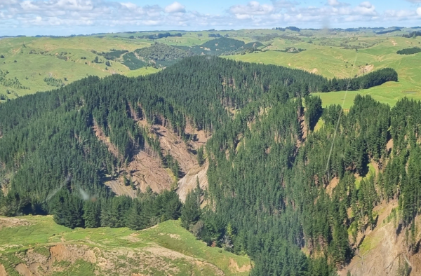
Image: Erosion in a pine plantation in Te Tairāwhiti. Matt McCloy, 2023
Severe tropical Cyclone Gabrielle hit the northern and eastern parts of the North Island, with a national state of emergency declared on 14 February 2023. It devastated the area with slips and flooding, and took the lives of 11 people. Over 300,000 landslides carried large volumes of soil from pasture and forest down the hills behind Te Tairāwhiti, Hawke’s Bay, Wairoa, and the Wairarapa. Each landslide moved about 1,000 tonnes of soil on average, the equivalent weight of 548 single-cab utes, and deposited it on floodplains and waterways below.
Forests played a role as natural infrastructure to help reduce the risk of erosion. Most of these landslides occurred where intense rainfall fell on steep land without protective forest cover (McMillan et al, 2023). Trees can protect erosion-prone landscapes during intensive storm events by providing a canopy that intercepts rainfall, reducing water in the soil, and increasing structural integrity by binding the soil together with their roots (Li et al, 2019; Phillips et al, 2018; Rey, 2021).
Before Cyclone Gabrielle, other storms have also caused devastating landslides in Te Tairāwhiti. The region is known for its extremely erodible land and has a long history of extreme weather carrying sediment and woody debris down its slopes. The impacts of Cyclone Bola (1988) showed a clear difference in landslide vulnerability between pastoral land and forested land (Marden, 2004).
Following this, a decades-long movement began to plant forests on the steep hills in the region, mainly converting pasture to production forest (Basher, 2013). For more context, see ‘Finding a way through disaster to environmental and economic sustainability’ in Our land 2021.
While the main driver of this planting post-Cyclone Bola was to stabilise highly erodible land, recently harvested forests in Te Tairāwhiti were a substantial source of landslides following Cyclone Gabrielle (Marden & Seymour, 2022; McMillan et al, 2023).
The type of forest has an impact on landslide probability. After Cyclone Gabrielle, in Hawke’s Bay and the Wairarapa hill country, it was estimated that land covered by indigenous forest was 90 percent less likely to slide than hill country pastoral land, while land under exotic forest was between 60 and 80 percent less likely to slide than hill country pastoral land. Coastal hill country in Te Tairāwhiti under indigenous forest was estimated to be 50 percent less likely to slide than hill country pastoral land; however, exotic forestry and pasture had similar estimated extents of land sliding in this region (McMillan et al, 2023). Generally, indigenous forest had less probability of landslides compared to other landcover types, relative to pasture (McMillan et al, 2023).
There are several possible reasons why exotic forestry and some native vegetation were less effective than indigenous forest at reducing landslide probability in Te Tairāwhiti and Hawke’s Bay. These reasons could include soil and rock type and rainfall intensity, alongside the age, density and maturity of vegetation cover at the time of the storm (Phillips et al, 2018). Other factors that can increase vulnerability to landslides include thin soils caused by a long erosion history, and forestry management practices such as non-thinning or multiple rotations of forestry (McMillan et al, 2023). While exotic tree species’ root systems can often outperform indigenous ones in reinforcing soil (Phillips et al, 2023), these erosion control benefits are lost when forests are harvested until trees in the next rotation have grown enough to close the forest canopy (Phillips et al, 2015).
The type of tree, the place it is planted in a catchment and the way it is managed all have consequences downstream. For example, when a forest is standing or harvested can determine the extent of erosion, sedimentation and flood impact in an extreme event. These considerations are crucial in planning decisions for forests as effective natural infrastructure.
The ways that we use the land, including for agriculture, forestry, and urban land uses, puts pressure on important ecosystems that support the wider landscape. This affects the state of these ecosystems, including soils, forests, floodplains, wetlands, dunes, and urban green spaces.
Soil is the foundation of land-based ecosystems, but soils in Aotearoa New Zealand face many challenges. The land has naturally high levels of soil erosion, which can be accelerated by deforestation, grazing animals, and intensive land use. Soil quality is also showing signs of impairment in many areas used for primary industries, and this can impact the receiving environment. Our versatile soils for food production have become more fragmented, and their availability has decreased. The area of exotic forest has also expanded, mostly with conversion of land that was typically used for agriculture.
Meanwhile, lowland ecosystems including scrub and lowland forests are vulnerable as they are located in areas commonly cleared for agriculture and urban development. Urban and agricultural development continues to encroach on our rivers and floodplains. Wetlands and coastal dunes are among our most degraded ecosystems, and losses and degradation continue today. Urban green spaces are also in decline and have lost a large amount of native vegetation. The decline in these ecosystems has placed pressure on the species living in them, leading to high levels of extinction threat to indigenous species.
Our monitoring often focuses on the extent of ecosystems or distinct characteristics of the environment, rather than the broader health (or integrity) of those environments. In te taiao (the environment) all things are connected and are integral to the well-functioning environment for now and the future, but by compartmentalising the environment, we can only tell part of the story. Broadening our understanding of the state of the environment to include the intrinsic connections between natural systems gives a more fulsome picture of how our environment is coping with pressures, and can further support the connections between the state of the environment and impacts on the things we care about.

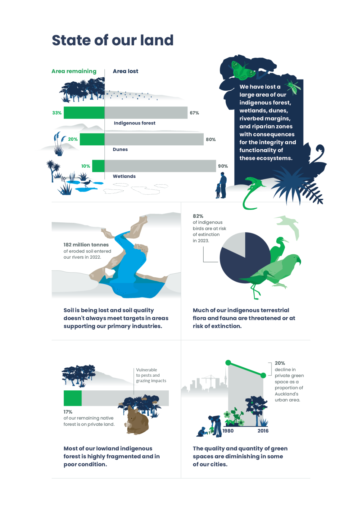
We have lost a large area of our indigenous forest, wetlands, dunes, riverbed margins, and riparian planting zones with consequences for the integrity and functionality of these ecosystems.
Soil is being lost and soil quality doesn’t always meet targets in areas supporting our primary industries.
Much of our indigenous terrestrial flora and fauna are threatened or at risk of extinction.
Most of our lowland indigenous forest is highly fragments and in poor condition.
The quality and quantity of green spaces are diminishing in some of our cities.
Soil is the foundation of all land-based ecosystems, from tussock grasslands and wetlands to forests and agricultural landscapes. Healthy soils support biodiversity, purify water, cycle nutrients, filter contaminants, and store carbon (Stevenson, 2022). From a mātauranga Māori (Māori knowledge) perspective, soil has an ancestral lineage that we are a part of (Harmsworth, 2022a).
Soil quality is monitored routinely through seven indicators encompassing both chemical and physical properties essential for plant growth and to maintain environmental quality. It is conducted across nine land uses, including those that support our primary industries (see Indicator: Soil quality and land use).
Target ranges are defined for each of the indicators that point to a compromise between optimal crop yield and fewest environmental impacts (for a full description of soil quality target ranges, see Our land 2021). Over 80 percent of measured sites did not meet targets for at least one indicator for 2014 to 2018 (see Indicator: Soil quality and land use and Our land 2021). But over 80 percent of sites were within their target ranges for four out of the seven indicators for the same period.
Macroporosity (a measure of soil compaction) was below the target range at 65 percent of measured dairy sites for the period 2014 to 2018. For drystock sites, 48 percent were below the macroporosity target. Low macroporosity indicates compacted soil that limits the flow of oxygen and water, which can impair plant growth. Compacted soil also increases the risk of sediment and pollutants flowing from land into water through surface runoff. Olsen phosphorus, which is a measure of soil fertility, was above the target range at 61 percent of monitored dairy sites (see Indicator: Soil quality and land use).*
Other studies also report issues with soil compaction and elevated levels of Olsen phosphorus (Houlbrooke et al, 2021; McDowell et al, 2020). For example, 63 percent of 450,000 soil samples collected between 2001 and 2015 had Olsen phosphorus levels above the target range (McDowell et al, 2020).
Looking at individual indicators does not tell the full story of how healthy our soils are. The concept of soil health takes a more comprehensive view of soil composition and ecosystems than soil quality. Soil health refers to a soil’s ongoing capacity to function as a living ecosystem that sustains microorganisms, plants, animals and humans (Harmsworth, 2022a). An estimated 59 (± 15) percent of the world’s biodiversity is found in soil (Anthony et al, 2023), yet our understanding of its effects on the wider environment are not well understood (Hermans et al, 2020) (see Our land 2021 and Environment Aotearoa 2022).
Measures of soil biodiversity, such as soil bacterial communities, have been identified as an encouraging bioindicator of soil quality that can improve our understanding of healthy soils, although soil biodiversity is not routinely monitored in Aotearoa (Hermans et al, 2020; Louisson et al, 2023). Similarly, preliminary target levels for earthworm abundances as indicators of soil health have been established for Aotearoa pastures (Schon et al, 2023). Intensive land use generally reduces soil biodiversity, but its effects on the environment more generally are not well understood (see Our land 2021). Diversity of microorganisms in the soil is lower at sites with a history of nitrogen fertilisation, which may limit future restoration of soil ecosystems and habitats (Addison et al, 2021).
Many core Māori values provide a strong basis for soil indicator development (Harmsworth, 2022a). Māori have differentiated soils for many years, with over 100 names for soil that help describe its qualities and characteristics, such as wetness, stoniness and colour. Understanding land quality, fertility and health centres on its ability to support life, health and wellbeing. Other factors considered important, based on a holistic approach, include the biology of soils, such as the quantity and health of microbes and organic matter (eg soil carbon) in the soil, the number of earthworms (eg worm counts per unit area or volume of soil), and other culturally important fauna and flora. Part of this is to learn the whakapapa (ancestral lineage) of the soil, and the interdependencies and interconnections between ecosystems, plants, animals and humans (Harmsworth, 2022a; Hsu et al, 2022).
* Note that the Stats NZ Indicator: Soil quality and land use reports on state and trends of environmental effects, using data from 13 regional authorities from 2014 to 2018. The indicator uses data from around 500 to 600 sites per soil variable. The Fertiliser Association of New Zealand (FANZ) has data for around 100,000 sites per year for Olsen phosphorus, used for fertiliser recommendations (FANZ, nd). The datasets are reported in different units and cannot be compared directly (Drewry et al, 2021).
About 14 percent (approximately 3,830,000 hectares) of our total land area has been classified as highly productive land (NZLRI, 2021; Rutledge et al, 2010). Between 2002 and 2019, highly productive land that had an urban or residential land use and so was unavailable for or restricted from use as farmland, increased 54 percent from 69,920 to 107,444 hectares (see Indicator: Land fragmentation). During this same period, highly productive land became more fragmented, with an increase in small-sized parcels (2 to 8 hectares) with a dwelling, representing an increase of 64,165 hectares (see Indicator: Land fragmentation). Smaller blocks of highly productive land, while still productive, are often shifted out of commercial production (Curran-Cournane et al, 2021a; Hart et al, 2013).
Highly productive land is a finite resource and converting it to housing is effectively irreversible, which means that the amount available can only remain stable or decline (Curran-Cournane et al, 2018; Curran-Cournane et al, 2021b). Highly productive land continues to be under pressure from land fragmentation and urban expansion.
In 2018, about half (12,635,000 hectares) of Aotearoa was covered with native ecosystems and the other approximate half (about 13,483,000 hectares) was covered with farms, pasture and plantation (exotic) forests (see Indicators: Indigenous land cover and Exotic land cover).
Exotic forests covered approximately 2.1 million hectares in 2018. The area of exotic forest in Aotearoa increased by 220,922 hectares (12 percent) between 1996 and 2018 (see Indicator: Exotic land cover). The Gisborne region showed the greatest increase in exotic forest area (measured in hectares) between 1996 and 2018, contributing to 20 percent of the increase for Aotearoa as a whole. The two regions with the most exotic forest by area, Waikato and Bay of Plenty, were also the only two regions that showed a decline in the amount of exotic forest between 1996 and 2018 (see Indicator: Exotic land cover).
There is a lot of uncertainty around wilding conifer area as it is hard to measure. Approximately 2 million hectares across Aotearoa are thought to be invaded by wilding conifers (Peltzer, 2018), with the affected area expanding by around 90,000 hectares a year (MPI, 2023e). The affected area includes grasslands, rare ecosystems, and subalpine habitats, with some areas being more densely or sparsely populated with wildings (MPI, 2014; Peltzer, 2018). Without management, wilding conifers will form dense forests and could invade about 25 percent of land in 30 years, threatening ecosystems across the landscape (MPI, 2023e).
Exotic forestry has expanded into pastoral hill country, typically used for agriculture, over the past few decades (Basher, 2013). Of land cover converted to exotic forest between 1996 and 2018, 75 percent was from exotic grassland (see Indicator: Exotic land cover).The area of exotic grassland decreased by 247,848 hectares (or 2 percent) between 1996 and 2008 and then increased by 68,274 hectares through to 2018 (see Indicator: Exotic land cover).
Aotearoa New Zealand’s indigenous land cover includes cover such as forests, tussock grasslands, and shrublands. The area of land covered with indigenous ecosystems continues to shrink, mainly through conversion to agriculture or forestry (see Indicator: Indigenous land cover). Net loss of indigenous land cover area is an ongoing trend: the area decreased by 12,689 hectares between 2012 and 2018. Among regions over the same period, Southland had the highest net loss at 3,944 hectares (see Indicator: Indigenous land cover). In Aotearoa, land covered with original or regenerating native vegetation ranges from vast areas of conservation land to small, isolated stands of regenerating bush on farms and in cities.
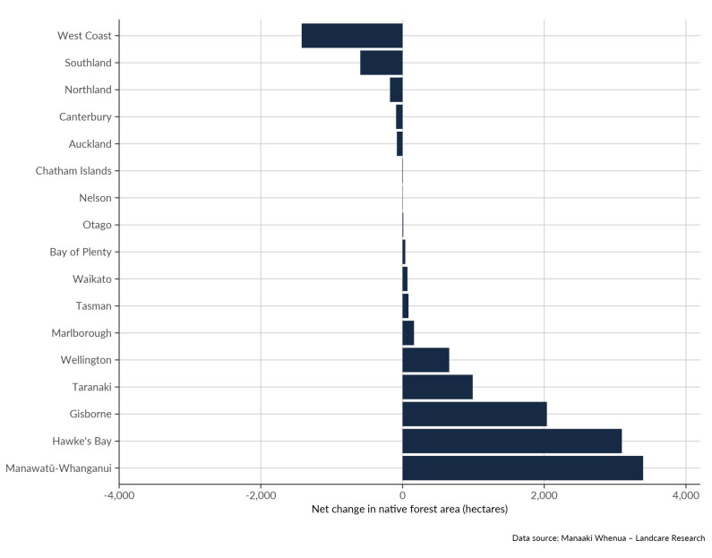
Before the arrival of humans, more than 80 percent of the land was covered with forest (see Indicator: Predicted pre-human vegetation). The area covered by indigenous forest has reduced to under 30 percent of Aotearoa New Zealand’s land area and has remained fairly stable since 1996 though regional changes have occurred. Some regions, including the West Coast and Southland, have seen net decreases. Other regions, including Manawatū-Whanganui, Hawke’s Bay, and Gisborne, have seen net gains in indigenous forest area (see figure 1 and Indicator: Indigenous land cover).
Meanwhile, indigenous scrub and shrubland decreased by 18,684 hectares between 2012 and 2018, with decreases occurring in every region. Where loss occurred, most of that land was converted to exotic grassland (52.3 percent) or exotic forest (19.9 percent). Tussock grassland also continued to decline between 2012 and 2018, but at a slower pace than previous periods, with 1,472 hectares lost (see Indicator: Indigenous land cover).
Lowland ecosystems, including scrub and lowland forests, are vulnerable as they are in areas commonly cleared for agriculture and urban development (Ausseil et al, 2011; Pannell et al, 2021; Walker et al, 2008). Although a significant portion of our native forests is legally safeguarded within protected conservation land, most of this is in upland areas (Cieraad et al, 2015; Pannell et al, 2021). Little of our lowland or coastal forest remains, and the primary land use in these areas is now pastoral farming (Ausseil et al, 2011; Ewers et al, 2006; Lyver et al, 2015). This has led to a disproportionate decline in the distinctive fauna and flora that the remaining forests can support (Walker et al, 2008, Walker et al, 2023).
Private land hosts a quarter of the remaining native vegetation nationwide, including 17 percent of native forest types that are under-represented in legally protected land. Sheep and beef farms, with their steep topography and lower livestock densities, safeguard more native vegetation than intensive farming does (Pannell et al, 2021). Much of our lowland indigenous forest within pastoral landscapes is fragmented and in poor condition, often due to lack of pest management and the impacts of grazing (Norton et al, 2020; Pannell et al, 2021).
Aotearoa experiences naturally high levels of soil erosion. Mass-movement erosion is the dominant type of erosion due to steep terrain, high rainfall, erodible geology, frequent intense rainstorms, and tectonic activity. These processes can be accelerated when human activities modify soil, vegetation or climatic conditions (Basher, 2013; Neverman et al, 2023). High rainfall and the mountainous terrain of the South Island influence natural erosion there, while in the North Island erosion driven mainly by mass movement is amplified by the clearance of forest for pastoral agriculture, particularly in vulnerable soft-rock pastoral hill country (Dymond, 2010 as cited in Neverman et al, 2023). Over 80 percent of all Māori land is hilly or mountainous and susceptible to major erosion events like landslides (Awatere et al, 2021).
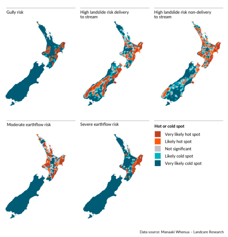
In 2022, 5 percent (12,693 square kilometres) of Aotearoa New Zealand’s land was classified as highly erodible land (see Indicator: Highly erodible land). This is land that is at risk of severe mass-movement erosion through landslide, or earthflow towards waterways, or at gully heads (see appendix B). Of these categories, land at risk of erosion through landslide represented 75 percent of the area at risk of erosion, corresponding to 4 percent of Aotearoa New Zealand’s total land area. Manawatū-Whanganui had the largest area of highly erodible land at risk of mass-movement erosion (2,208 square kilometres, which represents 17 percent of total highly erodible land at risk of erosion in Aotearoa) and had the greatest area in the country with high landslide risk (non-delivery to stream) (547 square kilometres) (see Indicator: Highly erodible land). Overall, it is estimated that 182 million tonnes of eroded soil entered Aotearoa New Zealand’s rivers in 2022 (see Indicator: Estimated long-term soil erosion).
The risk of erosion varies regionally. Of all regions, Gisborne had the highest proportion of its area classified as highly erodible land (15 percent, or 1,280 square kilometres). Of all regions, Gisborne also had the greatest areas with severe earthflow risk (228 square kilometres) and gully risk (161 square kilometres) (see Indicator: Highly erodible land). Gisborne has particularly high soil erosion due to very soft rock, which also means more sediment is delivered into rivers after storm events that cause mass-movement erosion (Dymond, 2010 as cited in Neverman et al, 2023; Dymond & Shepherd, 2023; MfE, 2024). Erosion risk is related to the levels of sediment movement into waterways, which were highest in the West Coast (48 million tonnes) and Gisborne (36 million tonnes) in 2022 (see Indicator: Estimated long-term soil erosion). The high soil erosion rates in the western Southern Alps are predominantly influenced by physical rock breakdown due to tectonic activity (Larsen et al, 2023).
Hot spots were identified in many areas across Aotearoa, representing areas with significantly higher proportions of highly erodible land at risk of erosion compared with Aotearoa on average. The five maps of Aotearoa in figure 2 show locations coloured according to whether an area is a hot spot or a cold spot for gully risk, high landslide risk (delivery to stream), high landslide risk (non-delivery to stream), moderate earthflow risk, and severe earthflow risk (see Indicator: Highly erodible land and appendix B).
In Aotearoa, modelling predicts a large increase in mass-movement erosion in soft-rock hill country with climate change, largely driven by increasing storm magnitude and frequency (Neverman et al, 2023). Localised studies find that grassland productivity can recover from the loss of soil in the decades following landslides, but only partially (Rosser & Ross, 2011). Production forests have a window of vulnerability after harvesting that can increase erosion risks (see case study: Our land use and management decisions have consequences in extreme weather events).
Floodplains play a significant role in supporting the broader ecological health of the catchments in which they are found (EEA, 2020). They are home to biologically rich habitats, providing spawning grounds for fish and vital areas for birds (Hibbert & Brown, 2001; EEA, 2020). For example, taonga (treasured) bird species like kakī (black stilt), ngutu pare (wrybill), tarapirohe (black-fronted tern) and tarāpuka (black-billed gull) depend almost exclusively on braidplains for nesting and breeding (DOC, nd-a). In addition to flood and erosion control, floodplains act as natural filters when inundated, effectively removing excess sediment and nutrients (Hicks et al, 2021; Peters, 2016). However, degradation of floodplains and braided rivers is decreasing their ability to provide these important habitats (Greenep & Parker, 2021; Hicks et al, 2021).
Our rivers and floodplains, including our rare and endangered braided rivers, face encroachment from development for urban and agricultural use (Abell et al, 2023; Brierley et al, 2022a; Greenep & Parker, 2021) (see Indicator: Rare ecosystems). Around 60 percent of braided river habitat is in Canterbury (Hibbert & Brown, 2001). Across the margins of low-plain braided rivers in Canterbury, 11,630 hectares of riverbed and riparian margins were converted for agricultural use between 1990 and 2012. From 2012 to 2019, this loss continued at an average rate of 178 hectares per year, with some braided river margins declining by as much as 80 percent (Greenep & Parker, 2021).
The use of stopbanks, engineered channels and other means of restricting the natural movement of a river has altered the hydrology of many of our river systems and disconnected waterways from their natural floodplains (Brierley et al, 2022a, 2022b; Crawford-Flett et al, 2022). This has resulted in loss of habitat, along with an associated decline in cultural and recreational amenity, and a decline in the natural flood and erosion benefits that those systems provide (Brierley et al, 2022a, 2022b) (see Our freshwater 2023). Our degraded rivers and floodplains will be subject to increased flood risk with an increase in extreme rainfall events and climate change (Hicks et al, 2021; MfE, 2008).
Dune and wetlands environments are home to many nationally and regionally threatened species. For example, wetlands are vital for the survival of many of our taonga bird species, including the tētē whero (brown teal), mātātā (New Zealand fernbird), koitareke (marsh crake), matuku-hūrepo (Australasian bittern) and kōtuku (white heron), who rely entirely on remaining wetlands (DOC, nd-b) (see Our freshwater 2023). These ecosystems filter large volumes of seawater, prevent floods and erosion, store carbon, process nutrients, and offer recreational, cultural and aesthetic value (Dymond et al, 2021; Ryan et al, 2023; Thompson, 2022).
Wetlands provide mahinga kai (traditional food-gathering practices), natural resources, and rongoā (medicine) (Taura et al, 2017, 2021), while coastal dunes have significant archaeological and recreational values. Wetlands are taonga (treasured) and reflect a deep history and kōrero (set of narratives) of whakapapa stories (pūrākau), offering crucial insights into the overall health of the entire ecosystem (Taura et al, 2021). Despite their significance, our wetlands and sand dunes are among our most degraded ecosystems in Aotearoa (Bataille et al, 2021; Dune Restoration Trust of New Zealand, 2011).
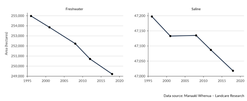
We have lost around 90 percent of our wetlands in the past 150 years, and this decline is continuing (Ausseil et al, 2011; Dymond et al, 2021). Between 1996 and 2018, saline wetland area decreased by 180 hectares (see figure 3). Over the same period, freshwater wetland area decreased by 5,761 hectares, with 87 percent of this loss occurring through conversion into grazing grassland (see Indicator: Wetland area). Our remaining wetlands continue to degrade due to drainage, pollution, increased sedimentation, invasive weeds, animal pests, and climate change (Denyer & Peters, 2020) (see Our freshwater 2023). In 2022, large areas of the Awarua, Kaimaumau-Motutangi and Waituna wetland were ravaged by fire, with climate change escalating fire risk (see Our atmosphere and climate 2023). In 2023, Whangamarino wetland experienced a botulism outbreak linked to a large die-off of fish and birds due to a high level of pollution (Waikato Regional Council, 2023).
Our dune ecosystems have also suffered extensive loss. In 2008, sand dunes covered 25,208 hectares of our land surface, an 80 percent decrease from the 1950s (see Indicator: Active sand dune extent). Marram grass (Ammophila arenaria) is a widespread introduced dune species and is a key threat to our remaining active dune systems, limiting their integrity and functionality. The cover of marram grass increased significantly between 1985 and 2005, largely due to intentional planting as a means of dune stabilisation (Hilton, 2006). Grazing, land development, pollution, erosion, coastal structures, and daily disturbances also contribute to the degradation of our remaining dune ecosystems (Thompson, 2022).
In some major cities, the availability of urban green space such as parks and green belts is not keeping pace with urban expansion. The expansion of Auckland, Hamilton and Wellington has consumed 60,000 hectares of peri-urban land in the past 80 years, and Auckland and Hamilton have grown less green through time. Private green space is also declining, and this trend is accelerating (PCE, 2023).
Our urban areas have also lost a large amount of native vegetation, contributing to a decline in ecological diversity and disrupting the natural balance in these environments (Jang & Woo, 2022; Rodgers et al, 2023).
The quality of urban green space determines how much we can benefit from it and in what ways. Lawns account for a significant portion of urban green space in some cities – half in Auckland and two-thirds in Hamilton. However, lawns provide fewer biophysical benefits than more diverse and complex green spaces. Higher-quality urban green spaces are those that are planted in adequate soil, are well maintained, and include wetlands and trees. These support air filtering, biodiversity, cooling and shading, stormwater control, and water filtering to a much greater extent than open grassed areas or spaces with low shrub (PCE, 2023, 2024).
Private green spaces in our cities are declining in area due to an ongoing shift toward denser infill housing and smaller sections and yards. The area of private green space, as a proportion of each city’s urban area, declined by around 20 percent in Auckland and 15 percent in Hamilton between 1980 and 2016 (PCE, 2023). Today, around 30 percent of Auckland’s urban area consists of private green space. Expected population growth and intensification could potentially reduce this area by 5 to 10 percent (3,000 hectares) over the next two decades (PCE, 2023).
Should present trends persist, the extent of existing parks and reserves is not expected to change significantly during future development. Conversely, ongoing intensification is likely to replace many lawns and private gardens with new dwellings or cover these green spaces with impermeable surfaces for vehicle access and parking. This will result in fewer large trees or diverse patches of bush in private gardens, impacting resilience to rainfall and flooding events (PCE, 2023, 2024). Land development in urban areas also reduces soil quality through over-compaction, as well as reducing the amount of topsoil and subsoil, which is often excavated to build foundations (PCE, 2024).
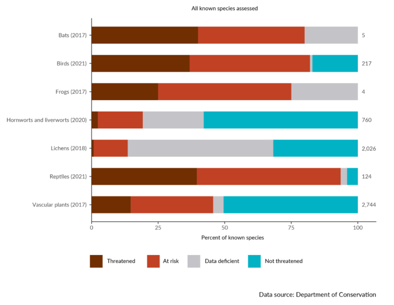
Indigenous ecosystems are important habitats for our unique species, which are also at risk from climate change, pollution and invasive species. The world is in a biodiversity crisis, with our unique biodiversity in Aotearoa declining (DOC, 2020; IPBES, 2019). In 2023, 94 percent (116 of 124) of our reptiles and 82 percent (178 of 217) of our birds were threatened with or at risk of extinction. Among vascular plants, 46 percent (1,253 of 2,744) were threatened or at risk. Further, many of our indigenous species are categorised as ‘data deficient’ (see figure 4) (see Indicator: Extinction threat to indigenous species).
Land supports our economy, food systems, resilience to natural hazards, health, and our cultural connections and practices related to te taiao (the environment). Our connection to, and reliance upon, our natural infrastructure means that we are impacted by changes to the state of soils, ecosystems and the species they support. When the health of our land comes under pressure, its ability to support us is diminished.
The current state of land environments means that our economy, grey infrastructure and natural environments are more vulnerable. While only some of these vulnerabilities are quantifiable, those that are show that our natural infrastructure is suffering significant losses due to soil erosion, droughts, landslides, floods and pest species.
Impacts related to biodiversity and our relationships to te taiao are more difficult to quantify. Qualitative evidence suggests that the decline in the health and extent of indigenous ecosystems is impacting cultural practices, our senses of identity and place, and our mental, physical, and spiritual health, and that these impacts are likely to continue.
Sustaining, restoring, and enhancing the natural infrastructure that supports us mitigates the impacts of environmental pressures, both for us and future generations.
The key pressures faced by our land environments are changes in land use, along with adverse effects from pollution, climate change, and invasive species.
Intense agriculture places pressure on the health of functioning of ecosystems.
Pests are a pressure on our native biodiversity and productive landscapes.
Climate change is a direct pressure that worsens the impact of other pressures.
Waste and contaminants place growing pressure on soil and water quality.
Highly productive land offers a wide range of land-use options and choices (Lynn et al, 2009) and is important due to its contribution as a major export earner for Aotearoa New Zealand (Curran-Cournane et al, 2021a). Horticulture, which has typically been located on highly productive land close to urban fringes (MPI, 2019), was the third-largest food and fibre sector export earner in 2023 (MPI, 2023c).
Due to its proximity to urban fringes, horticulture is particularly vulnerable to urban expansion and land fragmentation (Curran-Cournane et al, 2021a, Greenhalgh et al, 2017; MPI, 2019). Outdoor horticulture production and arable cropping are constrained by climate and a range of land and soil characteristics, which limit the ability to move horticulture and arable cropping elsewhere (Curran-Cournane & Rush, 2021; MPI, 2019).
Reducing the amount of highly productive land available for horticulture through urban expansion and land fragmentation can result in increased intensification on the remaining land resource (Deloitte, 2018; Curran-Cournane et al, 2021a). Intensive horticulture production systems can negatively impact the health of the soil and receiving environment (Curran-Cournane et al, 2021b; Norris et al, 2023).
The loss of highly productive land for food production could affect the price of fruit and vegetables (Deloitte, 2018). Alongside other factors, the reduced availability of highly productive land in the Auckland and Waikato District could contribute to an increase in fruit and vegetable prices of up to 58 percent across the country by 2043 (Deloitte, 2018).
The availability of highly productive land, and its sustainable management, contributes to food system resilience by supporting production of nutritious and diverse food (Curran-Cournane et al, 2021a; Curran-Cournane & Rush, 2021; Davis et al, 2023). Alongside reduced access to highly productive land, food production is facing increasing threats such as climate change, biosecurity risks and water access issues (Davis et al, 2023; Deloitte, 2018; Te Puna Whakaaronui, 2022).
The loss of highly productive land also means the loss of cultural and historic heritage, with 90 percent of our historical māra kai (gardening, horticulture) sites now removed or absent (Harmsworth, 2022b). Areas that were historically used by Māori for gardening were often located on highly productive land. There are extensive historical areas for māra kai where iwi and hapū Māori practiced horticulture and modified the soils for growing various crops (as cited in Harmsworth, 2022b: Coffin, 2020; Harmsworth & Roskruge, 2014; McFadgen, 1980).
Our economy and livelihood are embedded in nature. While some industries are more obviously reliant on nature, such as agriculture and forestry, every sector benefits from our natural ecosystems (Dasgupta, 2021). Examples of this interdependence include having a healthy workforce and strengthening our resilience to the impacts of extreme weather events (SBN, 2023).
Our food and fibre sector is an important part of our export economy. In the year ending June 2023, the sector (excluding seafood) accounted for $55.3 billion in export revenue, which represented over 75 percent of Aotearoa New Zealand’s total in export goods (MPI, 2023c). The sector is particularly susceptible to issues such as soil erosion, pests, diseases and the effects of climate change and extreme weather events (Dalziel et al, 2018) (see Our atmosphere and climate 2023).
The costs associated with landslides have been estimated to be at least $250–300 million a year (Page, 2015, as cited in Rosser et al, 2017). A case study in the Manawatū-Whanganui region estimated marginal costs of surficial and mass-movement erosion, showing higher relative marginal costs associated with erosion in vegetable, fruit and dairy land uses (Soliman & Walsh, 2020).
Weeds and invertebrate pests are compromising productivity in land-based industries. Intensified production systems may be more vulnerable to disruption by pests and diseases (Meurisse et al, 2023). The total economic costs of pests to Aotearoa were estimated at $9.2 billion in 2019/20 (2.9 percent of gross domestic product (GDP)), with about $4.3 billion attributed to losses in primary sector production (MPI, 2021). Climate change is creating more favourable conditions for overseas pests and diseases to establish and invade and can favour the geographical spread of pests and diseases that are already present in Aotearoa (Keegan et al, 2022) (see Our atmosphere and climate 2023).
Primary industries, particularly agriculture, are highly vulnerable to the effects of climate change – changes in temperature, rainfall patterns, and extreme weather events (see Our atmosphere and climate 2023). Natural disasters such as droughts, landslides and floods can cost Aotearoa billions annually (ICNZ, 2021). Estimated damages following Cyclone Gabrielle and the Auckland floods are between $9 billion and $14.5 billion (New Zealand Treasury, 2023). Estimated damage to the food and fibre sector alone from Cyclone Gabrielle may total between $700 million and $1.1 billion in recovery costs (MPI, 2023c). The growing number of extreme events can increase associated costs under climate change (see Our atmosphere and climate 2023). The Māori economy faces significant vulnerability as Māori own substantial shares in primary sector assets, including 40 percent of forestry assets (MFAT, 2019).
Forestry and wood processing employs a workforce of approximately 40,000 people (MPI, 2024). However, forestry plantations are particularly at risk from extreme events, many of which are projected to increase in severity and frequency (Villamor et al, 2023; Watt et al, 2019) (see Our atmosphere and climate 2023).
The condition of our natural infrastructure supports our natural environment’s aesthetic and recreational values, which are important attractions for visitors to our country. Where these values are degraded, there is risk to international tourism (PWC, 2023). Tourism directly contributed $13.3 billion, or 3.7 percent of GDP, to Aotearoa in the year ending March 2023 (Stats NZ, 2024c).
Measuring the costs of natural infrastructure degradation from an economic perspective often uses changes in GDP. This does not account for all the benefits our environment and natural infrastructure provide for us, including services like healthy soil, clean air and water, and pollination for food. Because of this, we often cannot measure and account for the full value of nature including the losses that are incurred when the environment is degraded (Bodey et al, 2022; Dasgupta, 2021).
The loss of our natural infrastructure contributes to vulnerability to hazards like flooding and fire (Munang et al, 2013).
Ongoing rural development and urban fringe expansion expose more people to wildfire threats due to proximity to highly flammable vegetation like ungrazed pastures or forestry plots in some areas (Huggins et al, 2020; Langer & Wegner, 2018; Langer et al, 2022). During the 2016/17 fire season, more homes were destroyed than had been in any of the previous 100 years, and this was surpassed in 2020/21 (Langer et al, 2021). Our changing climate is increasing the frequency and severity of wildfires and escalating the risks (Langer et al, 2021; Langer et al, 2022). Vegetation management and replacement with less flammable species on properties and community spaces can help reduce risk and slow the spread of fire (Langer et al, 2022).
Development near rivers can confine them to restricted spaces and increased flood risk. This puts communities and infrastructure at risk and limits flexibility to adapt to a changing climate (Hicks et al, 2021; Brierley et al, 2022b). It is estimated that more than 400,000 residential buildings, an estimated 12 percent of Aotearoa New Zealand’s housing value, are exposed to flooding in an extreme weather event (Paulik et al, 2023).
Impermeable surfaces in our urban areas limit the amount of water that soaks into the soil. Stormwater instead flows through pipes directly to waterways. Stormwater systems are only designed to cope with rain and runoff to specific levels, so are vulnerable to extreme weather events which can overwhelm them (Feng et al, 2021; PCE, 2023, 2024). We have seen this in recent extreme rainfall events. Our natural infrastructure, if in good health, is resilient to changing flow regimes (DPMC, 2023; MacKinnon et al, 2023). It has been estimated that urban vegetation can help soak up a third of the water from extreme rainfall events (PCE, 2023).
Coastal development has increased our vulnerability to rising seas. Sea-level rise is a direct consequence of climate change and is accelerating globally and in Aotearoa. When sea levels rose in the past, both dune systems and wetlands that protect our coasts migrated inland. Today, this migration is not possible in most places as it would threaten public and private assets and infrastructure built along our coasts (Thompson, 2022). An estimated 72,000 New Zealanders are currently exposed to present-day extreme coastal flooding, along with about 50,000 buildings worth $12.5 billion (NIWA, 2019) and 191 marae identified within 1 kilometre of the coastline (Bailey-Winiata, 2021).
Many of the environmental challenges facing Aotearoa today stem from the state of our land (Meyfroidt et al, 2022; Renwick et al, 2022). Healthy natural infrastructure protects and enhances the wider environmental system and the many interactions between land, climate, air, lakes, rivers and oceans (Bennett et al, 2016).
Land use plays a crucial role in the climate system and contributes significantly to global climate change. In Aotearoa, our agricultural sector accounted for 49 percent of our gross emissions in 2021, making it the largest contributor to our greenhouse gas emissions (MfE, 2023b) (see Our atmosphere and climate 2023).
Land ecosystems are offsetting some, but a decreasing percentage, of our emissions. Land use, land-use change and forestry offset 27 percent of gross greenhouse gas emissions in 2021 in Aotearoa. This was 4 percent less offset than in 1990 (MfE, 2023b) (see Our atmosphere and climate 2023).
Healthy peatlands and wetlands offer vast and long-term carbon storage potential (Ausseil et al, 2015). However, the degradation and drainage of these ecosystems for agriculture result in significant releases of stored organic carbon into the atmosphere for as long as they remain drained (Clarkson et al, 2013).
Trees act as carbon sinks, absorbing atmospheric carbon dioxide as they grow, and helping mitigate climate change (Zhang et al, 2022). Forests protect underlying soils from winds, the forest canopy protects from rainfall, and tree roots reinforce soil. Together they minimise the risk of mass-movement erosion (Basher, 2013; Li et al, 2019; Phillips et al, 2023; Rey, 2021). Differences in tree species, age, soil type, and climate affect the impact of the individual forest on erosion and carbon sequestration (Phillips et al, 2023; Zhang et al, 2022).
Exotic plantation forest can also bring challenges associated with intensification and management. These include slash production, loss of water-regulating functions, loss of sequestered carbon during clear-fell harvest, and adding to the risks of wildfire, pest invasion, and wilding pine spread (Himes et al, 2020; Jones et al, 2023; Messier et al, 2022). During harvest in each forestry rotation, a window of vulnerability occurs when the forest canopy and roots no longer provide services such as erosion mitigation (Phillips et al, 2015).
The ways that forests are managed and cleared on steep terrains have increased the loss of valuable topsoil and the amount of sediment debris and landslide materials entering rivers. This excess sediment further harms downstream freshwater and coastal ecosystems (Brierley et al, 2022a; Marshall et al, 2023).
Land-use practices for agriculture, forestry and urban development contribute significantly to declines in freshwater quality and biodiversity. Excess sediment, nutrient, pathogen and contaminant pollution harm our freshwater ecosystems (see Our freshwater 2023). Afforestation of catchments can reduce sediment loss and erosion and improve waterway health (Baillie & Neary, 2015; Basher, 2013; Drewry et al, 2022).
Our marine habitats and biodiversity are under threat from the discharge of land-based pollutants and sediments. For example, increased sedimentation can smother coastal habitats, such as nursery areas for fish and shellfish (Fisheries New Zealand, 2021) (see Our marine environment 2022).
Lowland indigenous forests are important habitats for a high proportion of our threatened native species (Walker et al, 2008). Some species occasionally persist in the remnant indigenous forest in pastoral systems, such as the brown kiwi in the North Island. However, species that need large, connected forest area, like the kōkako, are generally not present in these modified landscapes (Norton et al, 2020). The native biodiversity persisting in these modified landscapes performs important ecological functions such as pollination, water-quality mitigation, erosion control, and carbon sequestration, while also retaining cultural and heritage values, among other benefits (Case et al, 2023; Pannell et al, 2021).
Exotic plantation forests can also have some positive effects on native species by protecting the edges of native bush remnants and improving connections between them (Marshall et al, 2023). Planted exotic forest in Aotearoa can contain native ecosystem remnants and provide habitat for indigenous species where no alternative exists. For example, records show that up to 118 species classified as threatened by the Department of Conservation are found in plantation forests (Pawson et al, 2010). Of the species recorded in exotic forest, 16 are classified as ‘Nationally Critical’, 17 ‘Nationally Endangered’ and 17 ‘Nationally Vulnerable’ (Pawson et al, 2010). These species include bats, insect-eating birds such as riroriro (grey warbler), pīwakawaka (New Zealand fantail), and kiwi, and a wide variety of invertebrates found in leaf litter layers, soil and wood (MWLR, 2018).
The decline in the health of our natural infrastructure and biodiversity reduces the ability of our environment to recover from disturbances caused by extreme weather events, long-term environmental changes, and climate change (Key et al, 2022; Dasgupta, 2021). Studies have compared similar ecosystems that differ in their numbers of species. Those with more species, indicating healthier natural infrastructure, tend to be able to keep functioning in the face of environmental stress. This comes through an ‘insurance effect’ whereby at least some species are able to adapt to changing conditions and maintain essential ecosystem functions (Key et al, 2022).
We rely on our natural infrastructure to support our physical health. It provides us with food and water, regulates our climate and temperature, and reduces air and noise pollution (Meurk et al, 2013).
Our growing urban areas produce, absorb and retain more heat than outlying areas, which will make them even hotter as temperatures rise with climate change (IPCC, 2021). Urban heat can place stress on infrastructure and ecosystems, and worsen certain health conditions, particularly for older people and youth (PCE, 2023). Urban forests and green space lower temperatures through transpiration and shading buildings, reducing this urban heat island effect (PCE, 2023). Reductions in urban green space will widen health inequities, especially for lower-income communities who already have less access to diverse green spaces and the benefits they provide (PCE, 2023; Regional Public Health, 2010; Whitburn, 2014).
Urban trees also combat air pollution. It is estimated that trees in Auckland alone remove 1,230 tonnes of nitrogen dioxide, 1,990 tonnes of ozone, and 1,320 tonnes of particulate matter annually (PCE, 2023). This is important for public health because particulate matter (PM2.5) and nitrogen dioxide (NO2) from human-made air pollution were associated with an estimated 3,317 premature deaths and 13,155 hospitalisations in Aotearoa in 2016 (see Indicator: Human health impacts of PM2.5 and NO2). Natural infrastructure also contributes to carbon sequestration, thereby helping to reduce the diverse range of public health impacts related to climate change (see Our atmosphere and climate 2023).
Some land-use practices contaminate the rivers we swim in and collect kai (food) from. This can be through sediment loading, microbes from sewage discharge that infect humans and livestock, and runoff from farmland and urban areas (French et al, 2022). This contamination makes rivers unsafe for swimming and depletes the mauri (mauri is an important Māori concept that describes the health and vitality of living systems) of many mahinga kai (traditional food-gathering practices) areas. Some sites are under harvest bans because kai is not safe to eat (Clough, 2013; Morrison et al, 2023; van Hamelsveld et al, 2023) (see Our freshwater 2023).
Healthy soil in our gardens allows us to grow our own food. However, some urban and suburban soils are contaminated by heavy metals (Ashrafzadeh et al, 2018).
We rely on the natural world for recreation, building social connections, and supporting our mental and spiritual health (see Environment Aotearoa 2022). Land is an anchor for our collective identity and connection to land underpins Māori spirituality and health (Hond et al, 2019; Thom & Grimes, 2022). Our native ecosystems have scenic landscapes and unique wildlife and provide opportunities for recreation. A survey of over 3,800 New Zealanders about their experiences in the outdoors found that 84 percent of respondents felt having access to the outdoor spaces of Aotearoa is a major advantage of living here (DOC, 2020) (see Environment Aotearoa 2022).
Our increasing population continues to drive the demand for land to supply opportunities for recreation and to enjoy nature (see Our land 2021 and Environment Aotearoa 2022). Much of our population growth between 2018 and 2048 (likely 70 percent or more) will be in the main urban centres (Stats NZ, 2021). In cities such as Auckland and Hamilton, the amount of new green space being allocated is not keeping pace with urban development, meaning the proportion of green space available is shrinking (PCE, 2023).
Green spaces have been shown to promote good mental health, improve attention, reduce stress, and lower blood pressure and muscle tension (Hartig et al, 1991; Tzoulas et al, 2007; Ulrich, 1984). The importance of urban public green spaces was highlighted during COVID-19 lockdowns, when nearby parks and reserves were frequently visited by many people (Mackinnon et al, 2022; MfE, 2022). Living closer to green spaces has also been linked to decreased instances of anxiety and other mood disorders in urban populations (Nutsford et al, 2013).
The accessibility of urban green space for adolescents is associated with reductions in stress, substance problems, depressive symptoms, and psychological distress, as well as with improvements in mood, emotional wellbeing, and behaviour (Hobbs et al, 2023; Mavoa et al, 2019; McCormick, 2017; Tzoulas et al, 2007). This is important, as one-third of Aotearoa adolescents aged 15 to 17 years reported having difficulties in everyday activities, including communicating and social interaction, due to mental illness (HPA, 2020).
In te ao Māori (Māori worldview), people are related to their environment through whakapapa (ancestral lineage). These kinship relations to each other and within the natural world evoke reciprocity, active kaitiakitanga (the ethos of sustainable resource management, environmental guardianship) and the enduring aroha (love) and care for nature (Reihana et al, 2023). The importance of desirable, meaningful and reciprocal relationships between nature and humans reflected in te ao Māori has been adopted by the Treasury’s Living Standards Framework to capture broader dimensions of wellbeing.
The degradation of our land and ecosystems impacts te taiao as a whole and, by extension, our national identity in Aotearoa (see Environment Aotearoa 2022). Changes in land cover and biodiversity loss have reduced people’s attachment to their local environment over multiple generations. Loss of direct connection is particularly pronounced in urban spaces, where the loss of indigenous vegetation can cause disconnection from natural heritage and subsequent loss of identity and sense of place (Rodgers et al, 2023). Making natural heritage visible in urban areas, where most people live, can have many co-benefits beyond increasing biodiversity, through enhancing our connections to nature (Rodgers et al, 2023).
The degradation of our natural infrastructure and wider biodiversity reduces opportunities for connecting with and maintaining relationships with te taiao, including Māori knowledge and practices such as kaitiakitanga (Harmsworth, 2022b; Mark et al, 2022).
Damage or loss of culturally important sites, including rare ecosystems such as wetlands, affects community interactions and tikanga practices (Awatere et al, 2021; Harmsworth & Awatere, 2013) (see Our marine environment 2022). Maintaining connection to customary sites for food growing and gathering, such as mahinga kai and māra kai, supports relationships within local Māori communities, including in terms of identity, cultural revitalisation, social cohesion, intergenerational approaches to health promotion, and Māori resistance (Hond et al, 2019; Taura et al, 2017, 2021). Losing the ability to practise mahinga kai and the loss of access to relevant resources diminish mana (authority) (Awatere et al, 2021; Timoti et al, 2017).
Rongoā rākau (plant medicines) is integral to traditional Māori healing practices (Mark et al, 2022), and the plants necessary for these practices are vulnerable to changes in the landscape (Awatere et al, 2021; Marques et al, 2023). Many native plants have decreased in abundance or have been lost due to changes in land use and are under compounding pressures from introduced species, disease and climate change (Bond et al, 2019; DOC, 2020; Keegan et al, 2022). This can reduce rongoā practitioners’ ability to connect with and harvest the plants they need (Marques et al, 2023).
Important knowledge derived from cultural metaphors, pūrākau (stories), and Māori ancestral sayings (whakataukī) guide customary management of plants and animals – for example, practices around the cultivation of harakeke (flax) (Erueti et al, 2023; Wehi, 2009). Maintaining this knowledge and connection to taonga (treasured) species is reliant on species resilience and survival. For example, the loss of mana and retraction of mauri was observed with declining kererū populations in Te Urewera Forest (Timoti et al, 2017). This can impact the ability to uphold traditional roles and responsibilities to protect the environment, and reflects a decline in health of the whenua (land), forest and communities (Lyver et al, 2009; Timoti et al, 2017).
Loss of, or lack of access to, traditional lands has cultural, practical and economic implications for Māori land owners. Nationally, it is estimated that approximately 20 percent of Māori freehold land is landlocked, meaning that the piece of land has no reasonable access (Waitangi Tribunal, 2024). This prevents use and enjoyment of the land, makes it difficult to reconnect to historical knowledge, and challenges the duty to practise kaitiakitanga and care for te taiao (Hond et al, 2019; Mark et al, 2022; Waitangi Tribunal, 2024). The term ‘tangata whenua’ expresses an understanding of the relationship to land as one where Māori ‘belong’ to the land (Hond et al, 2019). Place names of natural landscapes hold the historical lineages of peoples, places and species that retain the community genealogy of place (Davis et al, 1990; Reihana et al, 2023). They serve as reminders of the past and indicators of previous events (King & Goff, 2006).
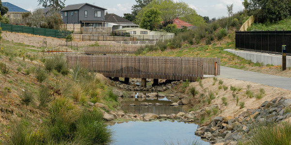
Image: Data source Te Auaunga, Oakley Creek. Kāinga Ora
Te Auaunga, known as ‘swirling waters’ or Oakley Creek, stands as the longest urban river, or awa, in the Auckland isthmus. It winds its way approximately 15 kilometres from the high ridgeline above Waikōwhai to the Waitematā Harbour (Kāinga Ora, 2023).
Two hundred years ago, the awa was nestled within a vibrant wetland named Te Wai-inu-roa o Rakataura, meaning ‘the long drink of Rakataura’. This wetland served as a habitat for taonga like native birds, fish and plants used in rongoā while Māori harvested abundant harakeke and raupō (bulrush) for textiles (Auckland Council, 2016). Papakāinga were sustained by the abundance of resource (Auckland Council, 2016). Te Wai-inu-roa o Rakataura also played a crucial role in flood mitigation and drainage (Kāinga Ora, 2023).
From the 1840s, settlers drained the wetland and cleared the forests, transforming the area into farmland and later residential space. In the 1930s, flood mitigation led to the straightening and deepening of Te Auaunga. By the mid-1950s, Te Auaunga was confined within concrete pipes and channels to prevent flood damage to houses built on the natural floodplain (Auckland Council, 2016). The continued development of housing through the 20th and early 21st centuries increased the amount of impermeable surfaces, causing increased water flows and erosion in the lower catchment (Auckland Council, 2018). The mauri of Te Auaunga stream had been much reduced; in its degraded state, it was unable to support the rich ecosystems of the wetland (Kāinga Ora, 2023).
Healthy Waters Auckland and six iwi authority groups led the flood management and restoration project for Te Auaunga, which began in 2015/16 with extensive local engagement (Auckland Council, 2018). The project prioritised a range of social, cultural and ecological outcomes alongside flood risk reduction (Auckland Council, 2020b).
Before restoration, flooding in the area was managed with a fast-flowing culvert. This frequently failed to safeguard nearby houses, which continued to endure damage following heavy rainfall events (Auckland Council, 2020b). The concrete flood management system was not only inadequate, but also unlikely to handle projected increases in stormwater volume caused by climate change (Auckland Council, nd).
Transforming the concrete infrastructure into a more natural stream and wetland involved removing basalt, realigning the stream, and replacing road culverts with bridges. Te Auaunga was widened to increase water-carrying capacity, thereby improving flood management for the surrounding area. Thousands of native plants provide natural water filtration and reduce pressure on downstream stormwater management systems by enabling more water to be absorbed (Auckland Council, nd). Community engagement led to the inclusion of cycle paths, walking trails and recreational spaces, with the result that more people used the park and they reported that the stream appears healthier (Auckland Council, 2020b).
Green infrastructure projects like Te Auaunga can have economic benefits as well. While sometimes having high upfront costs, they can be more cost-effective over time compared with grey infrastructure. The restoration of Te Auaunga employed 30 young people to construct and maintain the new infrastructure. It costs less to insure green than grey infrastructure and costs associated with damage from flooding are lower (Spicer, 2023).
Years of collaborative efforts on the project have united community groups, fostering a shared sense of identity linked to Te Auaunga and the revitalised parkway. After Cyclone Gabrielle, efforts from community groups and extra volunteers quickly helped clear debris and restore the area, showing their connection with Te Auaunga (Volunteering Auckland, 2023). This unity is further represented by an artwork named Te Tohu o Te Auaunga, which can be seen along the stream (Kāinga Ora, 2023).
In its restored state, Te Auaunga is again able to serve as natural infrastructure through improved flood management and water filtration, as well as providing an urban green space for the residents (Auckland Council, nd).
Nature’s worth to society – whether it is related to providing benefits to the economy, resilience, culture, identity or public health – is often not reflected in decision-making. Many of our actions that have an effect on ourselves and others, including future generations, therefore go unaccounted for and give rise to widespread ‘externalities’ or indirect costs (Dasgupta, 2021).
Knowledge has a critical role to play in giving visibility to all the benefits we receive from healthy ecosystems and functioning natural infrastructure. Below we highlight four key knowledge gaps that became apparent when compiling this report.
The drivers and pressures highlighted in ‘Pressures on our land’ do not act in isolation. Our decisions and actions on land use intersect with each other to create compounding pressures on biodiversity and people, many of which are increasingly amplified by climate change, invasive species and pollution.
What we do on the land has consequences for all other parts of the environment. Our impacts flow through our freshwater environments to our oceans and have cascading impacts that travel through our air and atmosphere. In many cases we still lack understanding of these relationships between cause and effect, and stress and response.
Modelling is one tool that can help us make sense of this complexity. Modelling crystallises our current understanding of connections, building on past changes to understand future changes and the consequences of our actions. Modelling can also offer a tool to fill gaps where measurements are challenging to make and can be used to inform indicators.
Advances in our computing environment and an increasing diversity of data, including new measurement approaches like satellite data or LiDAR, make integrated environmental modelling a viable opportunity to inform decision-making. However, more effort is needed to ensure that research models are suitable for use in policy and decision-making, including testing of assumptions and uncertainties.
Evaluation of the effect of interventions is essential to targeting investment and prioritising effort. We generally lack robust data to assess the extent to which everything – from national policy instruments to community-led initiatives – achieves its intended objectives and goals. This makes it challenging to attribute impacts to specific policies or innovations. It also limits the likelihood and confidence for outlook assessments.
We require an assessment approach that includes greater analysis of what effects policies have, and that can be applied across all environmental domains and knowledge systems, including mātauranga Māori (Māori knowledge).
To effectively translate indicators in ‘State of our land’ into measures in ‘Impacts on people and nature' requires different measures and therefore different monitoring approaches. Conventionally we monitor the abundance or extent of species and habitats such as threatened species or wetland extent, as noted in the ‘State of our land’.
The health and condition of ecosystems are typically less well monitored. There is also a lack of a common terminology and typology for ecosystems. Without this, it is difficult to build an estimate of how nature supports our economy, resilience, culture and public health.
Potential exists to draw on a wider range of indicators and knowledge, including qualitative and quantitative indicators and information. Collectively this information can help us understand the condition of natural infrastructure and how it relates to functional support and benefits to people.
This includes intergenerational Māori knowledge that spans over hundreds of years through a long and close association with te taiao (the environment). Many Māori communities have developed localised approaches for monitoring land environments, or indicators, based on various forms of knowledge and their values and worldviews. These approaches are fundamental for local communities to reduce or adapt to environmental pressures.
Quantifying the value of nature and natural infrastructure is challenging, particularly as our relationship with nature changes over time. It is also a challenge to describe this value in a currency that allows visibility within decision-making (eg in monetary terms). However, doing so is essential if we are to realise all the co-benefits, fully appreciate nature and draw on natural infrastructure as a viable alternative to conventional infrastructure solutions.
There are several reasons that the benefits of natural infrastructure can be difficult to quantify. There is a lack of standardised and endorsed method for economic non-market evaluation, and putting a monetary value on nature may not bring the best outcomes (Maechler & Boisvert, 2024). Economic valuation still struggles to capture many of the non-material benefits we receive from nature (NZIER, 2017). For example, it is challenging to quantify the value of urban green space in enhancing our relationship with nature and improving our physical and mental health. We could consider the avoided healthcare costs, but even this wouldn’t necessarily paint a representative picture that includes the co-benefits for our wellbeing, identity and culture, along with the inherent value of the ecosystem.
There are systems in use internationally that we could draw on to help capture this value. Most progress has been made where nature is viewed as a resource or asset, as is explored within Natural Capital Accounting, adopted in Australia and the European Union, or the System of Environmental-Economic Accounting (SEEA). Approaches such as True Cost Accounting can capture externalities to consider all hidden costs and benefits when it comes to how we use and manage land.
|
Probabilistic language |
Associated numeric probability |
|
Almost certain / Highly likely |
>90% |
|
Highly likely / Very probable / Likely |
75–85% |
|
Probable / Likely |
55–70% |
|
Realistic possibility |
25–50% |
|
Improbable / Unlikely |
15–20% |
|
Remote chance / Highly unlikely |
<10% |
|
High confidence |
Assessments are based on high-quality information, and/or the nature of the issue makes it possible to render a solid judgement. A ‘high confidence’ judgement is not a fact, however, and still carries a risk of being incorrect. |
|
Moderate confidence |
Assessments are based on credibly sourced and plausible information, but not of sufficient quality or corroboration to warrant a higher level of confidence. |
|
Low confidence |
Assessments are based on questionable or implausible information, the information is too fragmented or poorly corroborated to make solid analytic inferences, or significant concerns or problems with sources exist. |
Outlooks assessments contained in this report should not be read as statements of fact and may be based on a variety of sources of differing reliability. Certain words in this document are used to convey the probability of analytical assessments. These words are underlined in this report, to clearly identify assessments. These are used in conjunction with expressions of confidence, which provide an indication of the reliability and level of corroboration of sources used in an assessment. The language and probability ranges we use are the same as those of other government agencies, to maintain consistency.
The Highly Erodible Land (HEL) model identifies land at risk to the main forms of mass-movement soil erosion in Aotearoa New Zealand (landslide, earthflow and gully) if it does not have protective woody vegetation (Dymond et al, 2006). Figure 2 illustrates hot spots for this erosion.
The HEL model identifies five classes of land at risk of erosion:
These classes are not ranked in severity, except for earthflow risk, which has severe and moderate classes of risk.
Landslide erosion is the sudden failure of soil slopes during storm rainfall. Earthflow erosion is the slow downward movement of wet soil slopes towards waterways. Gully erosion is massive soil erosion that begins at gully heads and expands up hillsides over decadal time scales. See Indicator: Highly erodible land for more information.
Hot spot analysis identifies locations of statistically significant hot spots and cold spots in data by aggregating points of occurrence into polygons. This is one way to account for spatial autocorrelation. The analysis groups features together when similar high (hot) or low (cold) values are found in a cluster. We used hot spot analysis to analyse the data from the HEL model that use the ‘Woody layer’. The data cover all of Aotearoa at a resolution of 10 metre by 10 metre pixels and for seven consecutive years (2016–22). See Indicator: Highly erodible land for more information.
Listed below are the environmental indicators incorporated in this report, including two updated indicators shown in bold.
This report was compiled by the Ministry for the Environment and Stats NZ’s Environmental Reporting team.
We would like to thank the following for providing data and advice in the development of indicators used in this report:
Department of Conservation, district and regional councils, Health and air pollution in New Zealand 3.0, Intergovernmental Panel on Climate Change Centre for Environmental Data Analysis, Manaaki Whenua Landcare Research, National Institute for Water and Atmospheric Research, Stats NZ, Waka Kotahi NZ Transport Agency.
We would like to thank the following people and organisations for providing advice and helping to shape this report:
Ann Brower, Environmental Science, University of Canterbury
David Hall, Toha and School of Social Sciences and Humanities, Auckland University of Technology
Garth Harmsworth, Principal scientist, Toi Rangahau, Manaaki Whenua
Mahuru Wilcox, Manaaki Whenua Landcare Research
Shaun Awatere, Kaihautu Research Impact Leader, Manaaki Whenua Landcare Research
Troy Baisden, Motu Research and School of Environment, University of Auckland.
We would like to thank the following people and organisations for providing advice and critical review of an initial draft of this report:
Emily Afoa, Tektus Consultants Ltd
Justin Morgenroth, School of Forestry, University of Canterbury
Robyn Simcock, Manaaki Whenua Landcare Research
Tim Davie, Environment Canterbury.
The infographic and key fact pages were created by Dumpark Information Design.
Abell JM, Pingram MA, Özkundakci D, David BO, Scarsbrook M, Wilding T, Williams A, Noble M, Brasington J, & Perrie A. (2023). Large floodplain river restoration in New Zealand: Synthesis and critical evaluation to inform restoration planning and research. Regional Environmental Change, 23(1). https://doi.org/10.1007/s10113-022-01995-z
Addison SL, Smaill SJ, Garrett LG, & Wakelin SA. (2021). Fertiliser use has multi-decadal effects on microbial diversity and functionality of forest soils. Applied Soil Ecology, 163(February), 103964. https://doi.org/10.1016/j.apsoil.2021.103964
Anthony MA, Bender SF, & van der Heijden MGA. (2023). Enumerating soil biodiversity. Proceedings of the National Academy of Sciences, 120, 2017. https://doi.org/10.1073/pnas
Ashrafzadeh S, Lehto NJ, Oddy G, McLaren RG, Kang L, Dickinson NM, Welsch J, & Robinson BH. (2018). Heavy metals in suburban gardens and the implications of land-use change following a major earthquake. Applied Geochemistry, 88. https://doi.org/10.1016/j.apgeochem.2017.04.009
Auckland Council. (2016). Te Auaunga Awa (Oakley Creek) Vision and Restoration Strategy for the Upper Catchment Long Term Strategy. https://www.aucklandcouncil.govt.nz/about-auckland-council/how-auckland-council-works/local-boards/all-local-boards/puketapapa-local-board/Documents/te-auaunga-oakley-creek-vision-restoration-strategy.pdf
Auckland Council. (2018). Te Auaunga Awa (Oakley Creek) Vision and Restoration Strategy for the Lower Catchment Long Term Strategy. https://infocouncil.aucklandcouncil.govt.nz/Open/2018/09/AE_20180926_AGN_8223_AT_files/AE_20180926_AGN_8223_AT_Attachment_62334_1.PDF
Auckland Council. (2020a). Auckland Regional Pest Management Plan 2020–2030. https://www.aucklandcouncil.govt.nz/plans-projects-policies-reports-bylaws/our-plans-strategies/topic-based-plans-strategies/environmental-plans-strategies/docsregionalpestmanagementstrategy/auckland-regional-pest-management-plan-2020-2030.pdf
Auckland Council. (2020b). Te Auaunga Awa (Oakley Creek) Park and Stream Restoration Project: an Impact Evaluation. https://knowledgeauckland.org.nz/media/1857/tr2020-007-te-auaunga-awa-oakley-creek-impact-evaluation.pdf
Auckland Council. (nd). Green infrastructure. https://www.aucklandcouncil.govt.nz/plans-projects-policies-reports-bylaws/our-plans-strategies/auckland-plan/environment-cultural-heritage/Pages/green-infrastructure.aspx
Ausseil A-G Daigneault AJ, Frame B, & Teixeira EI. (2019a). Towards an integrated assessment of climate and socio-economic change impacts and implications in New Zealand. Environmental Modelling and Software, 119, 1–20. https://doi.org/10.1016/j.envsoft.2019.05.009
Ausseil, A-G, Dymond, JR, Kirschbaum, MUF, Andrew, RM, & Parfitt RL. (2013). Assessment of multiple ecosystem services in New Zealand at the catchment scale. Environmental Modelling and Software, 43, 37–48. https://doi.org/10.1016/j.envsoft.2013.01.006
Ausseil, A-G, Dymond, JR, & Weeks ES. (2011). Provision of Natural Habitat for Biodiversity: Quantifying Recent Trends in New Zealand. https://www.semanticscholar.org/paper/Provision-of-Natural-Habitat-for-Biodiversity%3A-in-Ausseil-Dymond/d6a149883b52eaf086a80ded32e852fdc1bb14de
Ausseil A-G, Jamali H, Clarkson BR, & Golubiewski NE. (2015). Soil carbon stocks in wetlands of New Zealand and impact of land conversion since European settlement. Wetlands Ecology and Management, 23(5), 947–961. https://doi.org/10.1007/s11273-015-9432-4
Ausseil A-G, van der Weerden T, Beare M, Teixeira E, Baisden T, Lieffering M, Guo J, Keller L, Law R, Noble A. (2019b). Climate change impacts on land use suitability. https://ourlandandwater.nz/wp-content/uploads/2019/11/LUS_Ausseil_Land-Use_Final-Report_FINAL-30-June-2019-1.pdf
Awasthi G, Nagar V, Mandzhieva S, Minkina T, Sankhla MS, Pandit PP, Aseri V, Awasthi KK, Rajput VD, Bauer T, & Srivastava S. (2022). Sustainable amelioration of heavy metals in soil ecosystem: Existing developments to emerging trends. Minerals, 12(1). https://doi.org/10.3390/min12010085
Awatere S, King DN, Reid J, Williams L, Masters-Awatere B, Harris P, Tassell-Matamua N, Jones R, Eastwood K, Pirker J, & Jackson A-M. (2021). He Huringa Āhuarangi, he Huringa Ao: A Changing Climate, a Changing World. http://www.maramatanga.co.nz/sites/default/files/project-reports/LC3948_Huringa.Oranga.Final_.Whiringaanuku_0.pdf
Bailey-Winiata, A. (2021). Understanding the Potential Exposure of Coastal Marae and Urupā in Aotearoa New Zealand to Sea Level Rise (Master’s thesis). https://researchcommons.waikato.ac.nz/bitstream/handle/10289/14567/thesis.pdf?sequence=4&isAllowed=y
Baillie BR, & Neary DG. (2015). Water quality in New Zealand’s planted forests: A review. New Zealand Journal of Forestry Science, 45(1). https://doi.org/10.1186/s40490-015-0040-0
Basher LR. (2013). Erosion processes and their control in New Zealand. In JR Dymond (Ed), Ecosystem Services in New Zealand: Conditions and Trends (pp 363–374). Manaaki Whenua Press. http://www.mwpress.co.nz/__data/assets/pdf_file/0004/77053/2_7_Basher.pdf
Bataille CY, Malinen SK, Yletyinen J, Scott N, & Lyver, POB. (2021). Relational values provide common ground and expose multi-level constraints to cross-cultural wetland management. People and Nature, 3(4), 941–960. https://doi.org/10.1002/pan3.10244
Bennett G, Cassin J, & Carroll N. (2016). Natural infrastructure investment and implications for the nexus: A global overview. Ecosystem Services, 17, 293–297. https://doi.org/10.1016/j.ecoser.2015.05.006
Bodeker, G, Cullen N, Katurji M, McDonald A, Morgenstern O, Noone D, Renwick J, Revell L, & Tait A. (2022). Aotearoa New Zealand Climate Change Projections Guidance: Interpreting the Latest IPCC WG1 Report Findings. https://environment.govt.nz/publications/aotearoa-new-zealand-climate-change-projections-guidance/
Bodey TW, Carter ZT, Haubrock PJ, Cuthbert RN, Welsh MJ, Diagne C, & Courchamp F. (2022). Building a synthesis of economic costs of biological invasions in New Zealand. PeerJ, 10. https://doi.org/10.7717/peerj.13580
Bond MO, Anderson BJ, Henare THA, & Wehi PM. (2019). Effects of climatically shifting species distributions on biocultural relationships. People and Nature, 1(1), 87–102. https://doi.org/10.1002/pan3.15
Brahney J, Hallerud M, Heim E, Hahnenberger M, & Sukumaran S. (2020). Plastic rain in protected areas of the United States. Science, 368(6496), 1257–1260. https://doi.org/10.1126/science.aaz5819
Brierley G, Fuller I, Williams G, Hikuroa D, & Tilley A. (2022a). Re-imagining wild rivers in Aotearoa New Zealand. Land, 11(8). https://doi.org/10.3390/land11081272
Brierley, GJ, Hikuroa D, Fuller IC, Tunnicliffe J, Allen K, Brasington J, Friedrich H, Hoyle J, & Measures R. (2022b). Reanimating the strangled rivers of Aotearoa New Zealand. Wiley Interdisciplinary Reviews: Water, 10(2). https://doi.org/10.1002/wat2.1624
Case B, Hall D, Day N, Hermans S, & Buckley H. (2023). What is the role of biodiversity in mediating the effects of climate change on New Zealand’s future agroecosystems? New Zealand Economic Papers, 57(2). https://doi.org/10.1080/00779954.2023.2191613
Cavanagh J, & Harmsworth G. (2023). An Implementation Framework for Ecological Soil Guideline Values. https://www.envirolink.govt.nz/assets/Envirolink/R18-1-An-implementation-framework-for-ecological-soil-guideline-values.pdf
Cieraad E, Walker S, Price R, & Barringer J. (2015). An updated assessment of indigenous cover remaining and legal protection in New Zealand’s land environments. New Zealand Journal of Ecology, 39(2), 309–315. https://newzealandecology.org/nzje/3235
Clarkson BD. (2022). Reversing biodiversity decline in Aotearoa New Zealand. Policy Quarterly, 18(2). https://doi.org/10.26686/pq.v18i2.7576
Clarkson B, Ausseil, A-G, & Gerbeaux, P. (2013). Wetland ecosystem services. In J. R. Dymond (Ed.), Ecosystem services in New Zealand – conditions and trends (pp 192–202). Manaaki Whenua Press. http://www.researchgate.net/profile/Anne-Gaelle_Ausseil/publication/260436894_Wetland_ecosystem_services/links/00b495314e583617c5000000.pdf
Clough P. (2013). The value of ecosystem services for recreation. In JR Dymond (Ed), Ecosystem Services in New Zealand. Manaaki Whenua Press. http://www.mwpress.co.nz/__data/assets/pdf_file/0019/77050/2_4_Clough.pdf
Coffin A. (2020). Ruia ngā purapura: Sowing the seeds. In Hutchings J, & Smith J. (Eds), Te Mahi Oneone Hua Parakore: A Māori Soil Sovereignty and Wellbeing Handbook (pp 122–131). Christchurch: Free Range Press.
Collins D, Woods R, Rouse H, Duncan M, Snelder T, & Cowie B. (2013). Water resource impacts and adaptation under climate change. Water Resources, 8.
Corbett, G. (2023). Bay of Plenty Regional Pest Management Plan 2020–2030. https://atlas.boprc.govt.nz/api/v1/edms/document/A4461148/content
Crawford-Flett K, Blake DM, Pascoal E, Wilson M, & Wotherspoon L. (2022). A standardised inventory for New Zealand’s stopbank (levee) network and its application for natural hazard exposure assessments. Journal of Flood Risk Management, 15(2). https://doi.org/10.1111/jfr3.12777
Curran-Cournane F, Carrick S, Barnes MG, Ausseil A-G, Drewry JJ, Bain IA, Golubiewski NE, Jones HS, Barringer J, & Morell L. (2021a). Cumulative effects of fragmentation and development on highly productive land in New Zealand. New Zealand Journal of Agricultural Research, 66(1), 1–24. https://doi.org/10.1080/00288233.2021.1918185
Curran-Cournane F, Donavan M, Merfield C, & Taitoko M. (2021b). Place-based approach to assessing the impact of Regenerative Agriculture in New Zealand. https://ourlandandwater.nz/outputs/place-based-approaches-to-assessing-the-impact-of-regenerative-agriculture-in-nz/
Curran-Cournane F, Golubiewski N, & Buckthought L. (2018). The odds appear stacked against versatile land: can we change them? New Zealand Journal of Agricultural Research, 61(3), 315–326. https://doi.org/10.1080/00288233.2018.1430590
Curran-Cournane F, & Rush E. (2021). Feeding the New Zealand Family of Five Million, 5+ a Day of Vegetables? Earth 2021, Vol. 2, pp 797-808, 2(4), 797–808. https://doi.org/10.3390/EARTH2040047
Dalziel P, Saunders C, & Saunders J. (2018). The New Zealand Food and Fibre Sector: A Situational Analysis. Client report prepared for: The Primary Sector Council. https://www.mpi.govt.nz/dmsdocument/33457-The-New-Zealand-Food-and-Fibre-Sector-A-Situational-Analysis-Report
Dasgupta P. (2021). Economics of Biodiversity: The Dasgupta Review: Headline Messages. https://assets.publishing.service.gov.uk/media/60182857d3bf7f70c2afe5bb/Dasgupta_Review_-_Headline_Messages.pdf
Davies C, & Sanesi G. (2022). COVID-19 and the importance of urban green spaces. Urban for Urban Green. https://www.ncbi.nlm.nih.gov/pmc/articles/PMC9212889/
Davis S, Chen G, & Darvill N. (2023). Housing and Food Production: Resident and Grower Perceptions of Peri-Urban Food-Production Landscapes. Land, 12(12), 2091. https://doi.org/10.3390/land12122091
Davis TA, O’Regan T, & Wilson J. (1990). Ngā Tohu Pūmahara – The Survey Pegs of the Past - Understanding Māori Place Names. New Zealand Geographical Board. https://www.linz.govt.nz/sites/default/files/nga-tohu-pumahara.pdf
Deloitte. (2018). New Zealand’s Food Story: The Pukekohe Hub. https://www.hortnz.co.nz/assets/Environment/National-Env-Policy/JR-Reference-Documents-/Deloitte-Pukekohe-Food-Story-Final-Report.pdf
Denyer K, & Peters M. (2020). The Root Causes of Wetland Loss in New Zealand: An Analysis of Public Policies & Processes. https://www.wetlandtrust.org.nz/wp-content/uploads/2021/02/ROOT-CAUSES-OF-WETLAND-LOSS-IN-NZ_Jan-2021.pdf
Diprose G, Kannemeyer R, Edwards P, & Greenaway A. (2022). Participatory biosecurity practices: Myrtle rust an unwanted pathogen in Aotearoa New Zealand. New Zealand Geographer, 78(3), 175–185. https://doi.org/10.1111/nzg.12347
DOC (Department of Conservation). (2011). Attitudes to Conservation. https://www.doc.govt.nz/globalassets/documents/about-doc/role/visitor-research/attitudes-to-conservation.pdf
DOC (Department of Conservation). (2020). Biodiversity in Aotearoa: An Overview of State, Trends and Pressures. https://www.doc.govt.nz/globalassets/documents/conservation/biodiversity/anzbs-2020-biodiversity-report.pdf
DOC. (Department of Conservation). (nd-a). Wetland and river birds. https://www.doc.govt.nz/nature/native-animals/birds/wetland-and-river-birds/
DOC (Department of Conservation). (nd-b). Why wetlands are important. https://www.doc.govt.nz/nature/habitats/wetlands/why-wetlands-are-important/
DPMC (Department of the Prime Minister and Cabinet). (2023). Strengthening the Resilience of Aotearoa New Zealand’s Critical Infrastructure System. https://consultation.dpmc.govt.nz/national-security-group/critical-infrastucture-phase-1-public-consultation/user_uploads/discussion-document--strengthening-the-resilience-of-nzs-ci-system.pdf
Drewry JJ, Stevenson BA, McNeill SJ, Cavanagh JE, & Taylor MD. (2021). Impact of volumetric versus gravimetric assessment on Olsen P concentrations. New Zealand Journal of Agricultural Research, 65(6), 463–483. https://doi.org/10.1080/00288233.2021.1912118
Drewry J, Stevenson B, Smith H, & Kannemeyer R. (2022). Soil Health Factsheet: Soil Erosion and Sediment Control. https://www.landcareresearch.co.nz/assets/Discover-Our-Research/Land/Soil-health-resilence/factsheet-erosion-sediment.pdf
Dune Restoration Trust of New Zealand. (2011). Why Do We Need to Restore Our Coastal Dunes? https://www.coastalrestorationtrust.org.nz/site/assets/files/1185/1.1_-_why_do_we_need_to_restore.pdf
Durie, M. (1998). Whaiora: Maori health development (2nd ed.). Auckland, N.Z.: Oxford University Press, 1998.
Dymond JR, Ausseil A-G, Shepherd JD, & Buettner L. (2006). Validation of a region-wide model of landslide susceptibility in the Manawatu–Wanganui region of New Zealand. Geomorphology, 74(1–4), 70–79. https://doi.org/10.1016/J.GEOMORPH.2005.08.005
Dymond JR. (2010). Soil erosion in New Zealand is a net sink of CO2. Earth Surface Processes and Landforms, 35(15), 1763–1772. https://doi.org/10.1002/esp.2014
Dymond JR, Sabetizade M, Newsome PF, Harmsworth, GR, & Ausseil A-G. (2021). Revised extent of wetlands in New Zealand. New Zealand Journal of Ecology, 45(2). https://doi.org/10.20423/nzjecol.45.32
Dymond J, & Shepherd J. (2023). Update to Highly Erodible Land and Estimated Long-term Soil Erosion data sets for Environmental Reporting. https://environment.govt.nz/assets/publications/Environmental-Reporting/Update-to-highly-erodible-land-and-estimated-long-term-soil-erosion-data-sets-for-environmental-reporting-2.pdf
Edwards, P, Stahlmann-Brown, P, & Thomas, S. (2020). Pernicious pests and public perceptions: Wilding conifers in Aotearoa New Zealand. Land Use Policy, 97, 104759. https://doi.org/10.1016/j.landusepol.2020.104759
EEA (European Environment Agency). (2020). Floodplains – a natural system to preserve and restore. https://www.eea.europa.eu/publications/floodplains-a-natural-system-to-preserve-and-restore
Erueti B, Tassell-Matamua N, Pomare P, Masters-Awatere B, Dell K, Te Rangi M, & Lindsay N. (2023). ‘Pūrākau o te Ngahere’: Indigenous Māori Interpretations, Expressions and Connection to Taonga Species and Biosecurity Issues. Knowledge Cultures, 11(1), 34–54. https://doi.org/10.22381/kc11120233
Etherington, TR, Peltzer, DA, & Wyse, SV. (2022). Future climates are predicted to alter the potential distributions of non-native conifer species in New Zealand. New Zealand Journal of Ecology, 46(1). https://doi.org/10.20417/nzjecol.46.14
Ewers RM, Kliskey AD, Walker S, Rutledge D, Harding JS, & Didham RK. (2006). Past and future trajectories of forest loss in New Zealand. Biological Conservation, 133(3), 312–325. https://doi.org/10.1016/j.biocon.2006.06.018
FANZ (Fertiliser Association New Zealand). (nd). New Zealand soil Olsen P levels. https://www.fertiliser.org.nz/Site/about/soil-health-fertility/nz-soil-olsen-p-levels.aspx
Feng B, Zhang Y, & Bourke R. (2021). Urbanization impacts on flood risks based on urban growth data and coupled flood models. Natural Hazards, 106(1). https://doi.org/10.1007/s11069-020-04480-0
Fisheries New Zealand. (2021). Aquatic Environment and Biodiversity Annual Review 2021. https://www.mpi.govt.nz/science/fisheries-research-and-science/about-our-fisheries-research/aquatic-environment-and-biodiversity-annual-review-aebar/
French R, Charon J, Lay C le, Muller C, & Holmes EC. (2022). Human land use impacts viral diversity and abundance in a New Zealand river. Virus Evolution, 8(1). https://doi.org/10.1093/ve/veac032
Froude, VA. (2011). Wilding Conifers in New Zealand: Beyond the status report. https://www.mpi.govt.nz/dmsdocument/51016-Wilding-conifers-in-New-Zealand-Beyond-the-status-report-December-2011
Goldson SL, Barker GM, Chapman HM, Popay AJ, Stewart AV, Caradus JR, & Barratt BIP. (2020). Severe insect pest impacts on New Zealand pasture: The plight of an ecological outlier. Journal of Insect Science, 20(2). https://doi.org/10.1093/JISESA/IEAA018
Greenep H, & Parker M. (2021). Land Use Change on the Margins of Lowland Canterbury Braided Rivers, 2012–2019. https://www.ecan.govt.nz/document/download?uri=4045059
Greenhalgh S, Samarasinghe O, Curran-Cournane F, Wright W, & Brown P. (2017). Using ecosystem services to underpin cost–benefit analysis: Is it a way to protect finite soil resources? Ecosystem Services, 27, 1–14. https://doi.org/10.1016/j.ecoser.2017.07.005
Grelet GA, Lang S, Merfield C, Calhoun N, Robson-Williams M, Anderson C, Anderson M, Apfelbaum S, Baisden T, Barry M, Beare M, Belliss S, Borrelli P, Bruce-Iri P, Bryant R, Buckley M, Burns E, Cavanagh J, Chan D, Clifford A, Clothier B, Conland N, Cournane-Curran F, Crampton E, Davidson M, Dewes A, Donovan M, Doolan-Noble F, Driver T, Dynes R, Fraser T, Garland C, Good, H, Gordon I, Greenhalgh S, Gregorini P, Gregory R, Griffin F, Harcombe M, Harmsworth G, Holdaway R, Horrocks A, Jones J, Kerner W., King J, King W, Kirk N, Kirschbaum M, Laubach J, Lavorel S, Le Heron E, Letica S, Lister C, Macmillan K, Maslen D, Mason N, Masters N, Matthews J, Mcglone M, McNally S, Mcneill S, Millard P, Minor M, Mudge P, Norton D, O’Connell S, Orwin K, Perley C, Phillips C, Pinxterhuis I, Price R, Rachel M, Rissman C, Roudier P, Saunders C, Saunders J, Schon N, Selbie D, Smith P, Stanley-Clarke N, Stephens T, Stevenson B, Stronge D, Su J, Tait P, & Taitoko M, Tapsell P, Teague R, Todd J & Vernon J. (2021). Regenerative agriculture in Aotearoa New Zealand – research pathways to build science-based evidence and national narratives. White paper prepared for Our Land and Water National Science Challenge and the NEXT Foundation. Lincoln, New Zealand: Manaaki Whenua – Landcare Research. https://hdl.handle.net/10182/13899
Harmsworth G. (2022a). Exploring Indigenous Māori Soil Health Concepts in Aotearoa-New Zealand.
Harmsworth G. (2022b). Soil Security: An Indigenous Māori Perspective from Aotearoa-New Zealand. https://www.researchgate.net/publication/367381014
Harmsworth GR, & Awatere S. (2013). Indigenous Māori knowledge and perspectives of ecosystems. In JR Dymond (Ed), Ecosystem Services in New Zealand. Manaaki Whenua Press. https://www.landcareresearch.co.nz/assets/Discover-Our-Research/Environment/Sustainable-society-policy/VMO/Indigenous_Maori_knowledge_perspectives_ecosystems.pdf
Harmsworth G, & Roskruge N. (2014). Indigenous Māori values, perspectives, and knowledge of soils in Aotearoa-New Zealand. In GJ Churchman & ER Landa (Eds), The Soil Underfoot: Infinite Possibilities for a Finite Resource (pp 112–124). CRC Press.
Hart G, Rutledge D, & Price R. (2013). Guidelines for Monitoring Land Fragmentation: Review of Knowledge, Issues, Policies, and Monitoring. Manaaki Whenua Landcare Research.
Hartig T, Mang M, & Evans GW. (1991). Restorative effects of natural environment experiences. Environmental Behaviour, 23, 3–26.
Hermans SM, Buckley HL, Case BS, Curran-Cournane F, Taylor M, & Lear G. (2020). Using soil bacterial communities to predict physico-chemical variables and soil quality. Microbiome, 8(1). https://doi.org/10.1186/s40168-020-00858-1
Hibbert, B, & Brown K. (2001). Braided river field guide. https://www.doc.govt.nz/globalassets/documents/conservation/land-and-freshwater/freshwater/prr/braided-river-field-guide.pdf
Hicks DM, Baynes ERC, Measures R, Stecca G, Tunnicliffe J, & Friedrich H. (2021). Morphodynamic research challenges for braided river environments: Lessons from the iconic case of New Zealand. Earth Surface Processes and Landforms, 46(1), 188–204. https://doi.org/10.1002/esp.5014
Hikuroa D, Clark J, Olsen A, & Camp E. (2018). Severed at the head: Towards revitalising the mauri of Te Awa o te Atua. New Zealand Journal of Marine and Freshwater Research 52(4), 643–656. https://doi.org/10.1080/00288330.2018.1532913
Hilton MJ. (2006). The loss of New Zealand’s active dunes and the spread of marram grass (Ammophila arenaria). New Zealand Geographer, 62(2), 105–120. https://doi.org/10.1111/j.1745-7939.2006.00054.x
Himes A, Puettmann K, & Muraca B. (2020). Trade-offs between ecosystem services along gradients of tree species diversity and values. Ecosystem Services, 44. https://doi.org/10.1016/j.ecoser.2020.101133
Hobbs M, Bowden N, Marek L, Wiki J, Kokaua J, Theodore R, Ruhe T, Boden J, Thabrew H, Hetrick S, & Milne B. (2023). The environment a young person grows up in is associated with their mental health: A nationwide geospatial study using the integrated data infrastructure, New Zealand. Social Science and Medicine, 326. https://doi.org/10.1016/j.socscimed.2023.115893
Hond R, Ratima M, & Edwards W. (2019). The role of Māori community gardens in health promotion: a land-based community development response by Tangata Whenua, people of their land. Global Health Promotion, 26(3_suppl), 44–53. https://doi.org/10.1177/1757975919831603
Houlbrooke D, Drewry J, Hu W, Laurensen S, & Carrick S. (2021). Soil structure: Its importance to resilient pastures in New Zealand (review). Journal of New Zealand Grasslands, 17, 201–212.
HPA (Health Promotion Agency). (2020). Mental Health in Aotearoa: Results from the 2018 Mental Health Monitor and the 2019/19 New Zealand Health Survey. https://www.hpa.org.nz/sites/default/files/Mental_Health_Aotearoa_Insight_2020.pdf
Hsu P-C, Schon ., & Hill R. (2022). Biological test of soil health using molecular techniques. https://ourlandandwater.nz/outputs/biological-test-of-soil-health-using-molecular-techniques-final-report/
Huggins TJ, Langer L, McLennan J, Johnston DM, & Yang L. (2020). The many-headed beast of wildfire risks in Aotearoa-New Zealand. Australian Journal of Emergency Management, 35(3), 48–53.
Hughes AO. (2016). Riparian management and stream bank erosion in New Zealand. In New Zealand Journal of Marine and Freshwater Research (Vol. 50, Issue 2, pp 277–290). Taylor and Francis Ltd. https://doi.org/10.1080/00288330.2015.1116449
Hulme PE. (2020). Plant invasions in New Zealand: global lessons in prevention, eradication and control. In Biological Invasions (Vol. 22, Issue 5, pp 1539–1562). Springer. https://doi.org/10.1007/s10530-020-02224-6
ICNZ (Insurance Council of New Zealand). (2021). Cost of natural disasters. https://www.icnz.org.nz/industry/cost-of-natural-disasters/
IPBES (Intergovernmental Science-Policy Platform on Biodiversity and Ecosystem Services). (2019). The global assessment report of the intergovernmental science-policy platform on biodiversity and ecosystem services. https://zenodo.org/records/6417333
IPBES (Intergovernmental Science-Policy Platform on Biodiversity and Ecosystem Services). (2022). Methodological Assessment Report on the Diverse Values and Valuation of Nature of the Intergovernmental Science-Policy Platform on Biodiversity and Ecosystem Services. https://doi.org/10.5281/zenodo.6522522
IPCC (Intergovernmental Panel on Climate Change). (2021). Regional Fact Sheet: Urban Areas. https://www.ipcc.ch/report/ar6/wg1/downloads/factsheets/IPCC_AR6_WGI_Regional_Fact_Sheet_Urban_areas.pdf
IPCC (Intergovernmental Panel on Climate Change). (2022). Australasia. In Climate Change 2022: Impacts, Adaptation and Vulnerability. Contribution of Working Group II to the Sixth Assessment Report of the Intergovernmental Panel on Climate Change (pp 1581–1688). https://doi.org/10.1017/9781009325844.013
IUCN (International Union for Conservation of Nature). (2021). Invasive Alien Species and Climate Change. https://www.iucn.org/sites/default/files/2022-04/ias_and_climate_change_issues_brief_2021.pdf
Jang J, & Woo SY. (2022). Native trees as a provider of vital urban ecosystem services in urbanizing New Zealand: Status quo, challenges and prospects. Land, 11, 92. https://doi.org/10.3390/land11010092
Jones AG, Cridge A, Fraser S, Holt L, Klinger S, McGregor KF, Paul T, Payn T, Scott MB, Yao RT, & Dickinson Y. (2023). Transitional forestry in New Zealand: Re-evaluating the design and management of forest systems through the lens of forest purpose. Biological Reviews, 98(4), 1003–1015. https://doi.org/10.1111/brv.12941
Kāinga Ora. (2023). The tale of Tohu: Te Tohu o Te Auaunga (the symbol of our awa). https://roskilldevelopment.co.nz/news/the-tale-of-tohu-te-tohu-o-te-auaunga-the-symbol-of-our-awa/
Keegan LJ, White RSA, & Macinnis-Ng C. (2022). Current knowledge and potential impacts of climate change on New Zealand’s biological heritage. New Zealand Journal of Ecology, 46(1). https://doi.org/10.20417/nzjecol.46.10
Key IB, Smith AC, Turner B, Chausson A, Girardin CAJ, Macgillivray M, & Seddon N. (2022). Biodiversity outcomes of nature-based solutions for climate change adaptation: Characterising the evidence base. Frontiers in Environmental Science, 10. https://doi.org/10.3389/fenvs.2022.905767
King DN, & Goff J. (2006). Māori Environmental Knowledge in Natural Hazards Management and Mitigation. https://niwa.co.nz/sites/niwa.co.nz/files/niwa_report_akl2006-055.pdf
Kotula H. (2022). Valuing Forest Ecosystem Services in New Zealand. https://motu-www.motu.org.nz/wpapers/22_11.pdf
Lambie SM, Awatere S, Daigneault A, Kirschbaum MUF, Marden M, Soliman T, Spiekermann RI, & Walsh PJ. (2021). Trade-offs between environmental and economic factors in conversion from exotic pine production to natural regeneration on erosion prone land. New Zealand Journal of Forestry Science, 51. https://doi.org/10.33494/nzjfs512021x163x
Langer L, & Wegner S. (2018). Wildfire risk awareness, perception and preparedness in the urban fringe in Aotearoa/New Zealand: Public responses to the 2017 Port Hills wildfire. Australasian Journal of Disaster and Trauma Studies.
Langer L, Wegner S, & Grant A. (2022). Risk perception and preparedness in a high-wildfire risk community: case study of Northern Wānaka/Albert Town, Otago. Scion Fire Technology Transfer Note, 46.
Langer L, Wegner S, & Pearce G. (2021). Preparing homeowners and communities in the rural-urban interface for increasing wildfire risk. https://www.ruralfireresearch.co.nz/__data/assets/pdf_file/0004/78664/RFR_tech_note_45.pdf
Larsen IJ, Eger A, Almond PC, Thaler EA, Rhodes JM, & Prasicek G. (2023). The influence of erosion and vegetation on soil production and chemical weathering rates in the Southern Alps, New Zealand. Earth and Planetary Science Letters, 608. https://doi.org/10.1016/j.epsl.2023.118036
Li G, Wan L, Cui M, Wu B, & Zhou J. (2019). Influence of canopy interception and rainfall kinetic energy on soil erosion under forests. Forests, 10(6). https://doi.org/10.3390/f10060509
Litter Intelligence. (n.d.). Data. Retrieved April 4, 2024, from https://litterintelligence.org/data/
Louisson Z, Hermans SM, Buckley HL, Case BS, Taylor M, Curran-Cournane F, & Lear G. (2023). Land use modification causes slow, but predictable, change in soil microbial community composition and functional potential. Environmental Microbiome, 18(1). https://doi.org/10.1186/s40793-023-00485-x
Lwanga EH, Beriot N, Corradini F, Silva V, Yang X, Baartman J, Rezaei M, van Schaik L, Riksen M, & Geissen V. (2022). Review of microplastic sources, transport pathways and correlations with other soil stressors: A journey from agricultural sites into the environment. Chemical and Biological Technologies in Agriculture, 9(1). https://doi.org/10.1186/s40538-021-00278-9
Lynn I, Manderson A, Page M, Harmsworth G, Eyles G, Douglas G, Mackay A, & Newsome P. (2009). Land Use Capability Survey Handbook: A New Zealand Handbook for the Classification of Land (3rd edition). AgResearch Ltd, Manaaki Whenua – Landcare Research and Institute of Geological and Nuclear Sciences Ltd.
Lyver PO, Jones CJ, & Doherty J. (2009). Flavor or forethought: Tuhoe traditional management strategies for the conservation of kereru (Hemiphaga novaeseelandiae novaeseelandiae) in New Zealand. Ecology and Society, 14(1). https://www.jstor.org/stable/26268038?seq=4
Lyver PO, Wilmshurst JM, Wood JR, Jones CJ, Fromont M, Bellingham PJ, Stone C, Sheehan M, & Moller H. (2015). Looking back for the future: Local knowledge and palaeoecology inform biocultural restoration of coastal ecosystems in New Zealand. Human Ecology, 43(5), 681–695. https://doi.org/10.1007/s10745-015-9784-7
Macinnis-Ng C, Mcintosh AR, Monks JM, Waipara N, White RSA, Boudjelas S, Clark CD, Clearwater MJ, Curran TJ, Dickinson KJM, Nelson N, Perry GLW, Richardson SJ, Stanley MC, & Peltzer DA. (2021). Climate-change impacts exacerbate conservation threats in island systems: New Zealand as a case study. Frontiers in Ecology and the Environment, 19(4), 216–224. https://doi.org/10.1002/fee.2285
Mackinnon M, Mackinnon R, Zari MP, Glensor K, & Park T. (2022). Urgent biophilia: Green space visits in Wellington, New Zealand, during the COVID-19 lockdowns. Land, 11(6). https://doi.org/10.3390/land11060793
MacKinnon M, Pedersen Zari M, Brown DK, Benavidez R, & Jackson B. (2023). Urban biomimicry for flood mitigation using an ecosystem service assessment tool in central Wellington, New Zealand. Biomimetics, 8(1). https://doi.org/10.3390/biomimetics8010009
MacLeod CJ, & Moller, H. (2006). Intensification and diversification of New Zealand agriculture since 1960: An evaluation of current indicators of land use change. Agriculture, Ecosystems & Environment, 115(1–4): 201–218.
Maechler S, & Boisvert V. (2024). Valuing Nature to Save It? The Centrality of Valuation in the New Spirit of Conservation. Global Environmental Politics, 24(1), 10–30. https://doi.org/10.1162/glep_a_00734
Manderson A. (2020). Scoping a national land-use intensity indicator. https://environment.govt.nz/assets/Publications/Files/scoping-a-national-land-use-intensity-indicator.pdf
Marden M. (2004). Future-proofing erosion-prone hill country against soil degradation and loss during storm events: have past lesson been heeded? https://www.uvm.edu/~pbierman/classes/gradsem/2005/papers/marden_2004_NZJF.pdf
Marden M, & Seymour A. (2022). Effectiveness of vegetative mitigation strategies in the restoration of fluvial and fluvio-mass movement gully complexes over 60 years, East Coast region, North Island, New Zealand. New Zealand Journal of Forestry Science, 52. https://doi.org/10.33494/nzjfs522022x226x
Mark G, Boulton A, Allport T, Kerridge D, & Potaka-Osborne G. (2022). “Ko au te whenua, ko te whenua ko au: I Am the land, and the land is me”: Healer/patient views on the role of rongoā Māori (traditional Māori healing) in healing the land. International Journal of Environmental Research and Public Health, 19(14). https://doi.org/10.3390/ijerph19148547
Marques B, McIntosh J, & Hall C. (2023). Cross-cultural rongoā healing: A landscape response to urban health. Landscape Research, 48(8), 1091–1107. https://doi.org/10.1080/01426397.2023.2230909
Marshall GR, Wyse SV, Manley BR, & Forbes AS. (2023). International use of exotic plantations for native forest restoration and implications for Aotearoa New Zealand. New Zealand Journal of Ecology, 47(1). https://doi.org/10.20417/nzjecol.47.3516
Maseyk F F, Dominati EJ, White T, & Mackay A.D. (2017). Farmer perspectives of the on-farm and off-farm pros and cons of planted multifunctional riparian margins. Land Use Policy, 61, 160–170. https://doi.org/10.1016/j.landusepol.2016.10.053
Mavoa S, Lucassen M, Denny S, Utter J, Clark T, & Smith M. (2019). Natural neighbourhood environments and the emotional health of urban New Zealand adolescents. Landscape and Urban Planning, 191. https://doi.org/10.1016/j.landurbplan.2019.103638
McCormick R. (2017). Does Access to Green Space Impact the Mental Well-being of Children: A Systematic Review. https://www.sciencedirect.com/science/article/abs/pii/S0882596317301859
McDowell RW, Dodd R, Pletnyakov P, & Noble A. (2020). The ability to reduce soil legacy phosphorus at a country scale. Frontiers in Environmental Science, 8, 6.
McFadgen BG. (1980). Maori Plaggen soils in New Zealand, their origin and properties. Journal of the Royal Society of New Zealand, 10(1), 3–18. https://doi.org/10.1080/03036758.1980.10426547
McGlone MS, Bellingham PJ, & Richardson SJ. (2022). Science, policy, and sustainable indigenous forestry in New Zealand. New Zealand Journal of Forestry Science, 52. https://doi.org/10.33494/nzjfs522022x182x
McGowan R. (2021). Papatuanuku, Earth Mother: Indigenous knowledge in 21st century soil management. Soil Research, 59(6), 525–528. https://doi.org/10.1071/SR20260
McMillan A, Dymond J, Jolly B, Shepherd J, Sutherland A, & Belliss S. (2023). Rapid Assessment of Land Damage – Cyclone Gabrielle. Manaaki Whenua Landcare Research. https://environment.govt.nz/assets/Rapid-assessment-of-land-damage-Cyclone-Gabrielle-Manaaki-Whenua-Landcare-Research-report.pdf
Mead HM (2003). Tikanga Māori: Living by Māori Values. Huia.
Messier C, Bauhus J, Sousa-Silva R, Auge H, Baeten L, Barsoum N, Bruelheide H, Caldwell B, Cavender-Bares J, Dhiedt E, Eisenhauer N, Ganade G, Gravel D, Guillemot J, Hall JS, Hector A, Hérault B, Jactel H, Koricheva J, … Zemp DC. (2022). For the sake of resilience and multifunctionality, let’s diversify planted forests! Conservation Letters, 15(1). https://doi.org/10.1111/conl.12829
Meurisse N, Kean J, Vereijssen J, & Phillips C. (2023). Global change and NZ biosecurity: Risks and economics of future climates and trade patterns. B3: Science Solutions for Better Border Security. https://www.b3nz.org.nz/projects/global-change-and-nz-biosecurity-risks-and-economics-of-future-climates-and-trade-patterns/
Meurk C D, Blaschke PM, & Simcock RC. (2013). Ecosystem services in New Zealand cities. In JR Dymond (Ed), Ecosystem Services in New Zealand: Conditions and Trends (pp 254–273). Manaaki Whenua Press. http://www.mwpress.co.nz/__data/assets/pdf_file/0006/77046/1_18_Meurk.pdf
Meyfroidt P, de Bremond A, Ryan CM, Archer E, Aspinall R, Chhabra A, Camara G, Corbera E, DeFries R, Díaz S, Dong J, Ellis EC, Erb KH, Fisher JA, Garrett RD, Golubiewski NE, Grau HR, Grove JM, Haberl H, … zu Ermgassen EKHJ. (2022). Ten facts about land systems for sustainability. Proceedings of the National Academy of Sciences of the United States of America, 119(7). https://doi.org/10.1073/pnas.2109217118
MFAT (Ministry of Foreign Affairs and Trade). (2019). Te Ōhanga Māori: The Māori Economy. https://www.mfat.govt.nz/assets/Trade-agreements/UK-NZ-FTA/The-Maori-Economy_2.pdf
MfE (Ministry for the Environment). (2004). Module 2. Hazardous waste guidelines: landfill waste acceptance criteria and landfill classification. Ministry for the Environment. https://environment.govt.nz/assets/Publications/Files/haz-waste-guide-module-2-may04.pdf
MfE (Ministry for the Environment). (2008). Meeting the challenges of future flooding in New Zealand. https://environment.govt.nz/assets/Publications/Files/meeting-challenges-of-future-flooding-in-nz.pdf
MfE (Ministry for the Environment). (2021). What is contaminated land? https://environment.govt.nz/facts-and-science/land/contaminated-land/
MfE (Ministry for the Environment. (2022). Value of Nature for Wellbeing during Times of Crisis: COVID-19 Case Study. https://environment.govt.nz/publications/value-of-nature-for-wellbeing-during-times-of-crisis/
MfE (Ministry for the Environment). (2023a). National monitoring system. https://environment.govt.nz/what-government-is-doing/areas-of-work/rma/national-monitoring-system/
MfE (Ministry for the Environment). (2023b). New Zealand’s Greenhouse Gas Inventory 1990–2021. https://environment.govt.nz/publications/new-zealands-greenhouse-gas-inventory-1990-2021
MfE (Ministry for the Environment). (2023c). Waste facilities and disposal. https://environment.govt.nz/facts-and-science/waste/waste-facilities-and-disposal/
Monaghan R, Manderson A, Basher L, Spiekermann R, Dymond J, Smith C, Muirhead R, Burger D, & McDowell R. (2021). Quantifying contaminant losses to water from pastoral landuses in New Zealand II. The effects of some farm mitigation actions over the past two decades. New Zealand Journal of Agricultural Research, 64(3), 365–389. https://doi.org/10.1080/00288233.2021.1876741
Mora-Teddy AK, & Matthaei CD. (2020). Microplastic pollution in urban streams across New Zealand: Concentrations, composition and implications. New Zealand Journal of Marine and Freshwater Research, 54(2), 233–250. https://doi.org/10.1080/00288330.2019.1703015
Morais S, Fonseca HMAC, Oliveira SMR, Oliveira H, Gupta VK, Sharma B, & Pereira M de L. (2021). Environmental and health hazards of chromated copper arsenate-treated wood: A review. In International Journal of Environmental Research and Public Health (Vol. 18, Issue 11). MDPI AG. https://doi.org/10.3390/ijerph18115518
Morgan TKKB. (2006). Decision-support tools and the indigenous paradigm. Engineering and Sustainability, 159(ES4), 167–177. http://dx.doi.org/10.1680/ensu.2006.159.4.169
Morrison M, Hughes A, Kainamu A, & Williams E. (2023). Land-based Effects on Coastal Fisheries and Kaimoana and Their Habitats: A Review. https://www.mpi.govt.nz/dmsdocument/56425/direct
MPI (Ministry for Primary Industries). (2014). The right tree in the right place New Zealand Wilding Conifer Management Strategy. https://www.mpi.govt.nz/dmsdocument/51013-The-wilding-conifer-management-strategy-20152030
MPI (Ministry for Primary Industries). (2019). Valuing highly productive land: A discussion document on a proposed national policy statement for highly productive land. https://www.mpi.govt.nz/dmsdocument/36624-discussion-document-on-a-proposed-national-policy-statement-for-highly-productive-land
MPI (Ministry for Primary Industries). (2021). Economic Costs of Pests to New Zealand: 2020 Update. https://www.mpi.govt.nz/dmsdocument/48496-Economic-costs-of-pests-to-New-Zealand-Technical-report
MPI (Ministry for Primary Industries). (2022a). National Direction for Plantation and Exotic Carbon Afforestation. https://www.mpi.govt.nz/consultations/national-direction-for-plantation-and-exotic-carbon-afforestation/
MPI (Ministry for Primary Industries). (2022b). Regenerating Aotearoa: Investigating the impacts of regenerative farming practices Ministry for Primary Industries Regenerating Aotearoa: Investigating the impacts of regenerative farming practices. https://www.mpi.govt.nz/dmsdocument/52975-Regenerating-Aotearoa-Investigating-the-impacts-of-regenerative-farming-practices
MPI (Ministry for Primary Industries). (2023a). Our work to keep pests and diseases out of NZ. https://www.mpi.govt.nz/biosecurity/about-biosecurity-in-new-zealand/our-work-to-keep-pests-and-diseases-out-of-nz/
MPI (Ministry for Primary Industries). (2023b). National Exotic Forest Description: as at 1 April 2022. https://www.mpi.govt.nz/dmsdocument/55996/direct
MPI (Ministry for Primary Industries). (2023c). Situation and Outlook for Primary Industries (SOPI) December 2023. https://www.mpi.govt.nz/dmsdocument/60526-Situation-and-Outlook-for-Primary-Industries-SOPI-December-2023
MPI (Ministry for Primary Industries). (2023d). The Future of Aotearoa New Zealand’s Food Sector: Exploring Global Demand Opportunities in the Year 2050. https://www.mpi.govt.nz/dmsdocument/56350-The-Future-of-Aotearoa-New-Zealands-Food-Sector-Exploring-Global-Demand-Opportunities-in-the-Year-2050
MPI (Ministry for Primary Industries). (2023e). Wilding conifer control in NZ. https://www.mpi.govt.nz/biosecurity/exotic-pests-and-diseases-in-new-zealand/long-term-biosecurity-management-programmes/wilding-conifers/
MPI (Ministry for Primary Industries). (2024). Forestry and Wood Processing Data. https://www.mpi.govt.nz/forestry/forest-industry-and-workforce/forestry-wood-processing-data
Munang R, Thiaw I, Alverson K, Liu J, & Han Z. (2013). The role of ecosystem services in climate change adaptation and disaster risk reduction. Current Opinion in Environmental Sustainability, 5(1), 47–52.
MWLR (Manaaki Whenua Landcare Research). (2018). Conserving Indigenous Fauna within Production Forestry Landscapes. Contract Report: LC3216. https://www.waikatoregion.govt.nz/assets/Envirolink/Reports/1854-GSDC150-Conserving-indigenous-fauna-within-production-forestry-landscapes.pdf
New Zealand Treasury. (2023). Impacts from the North Island weather events. https://www.treasury.govt.nz/sites/default/files/2023-04/impacts-from-the-north-island-weather-events.pdf
Neverman AJ, Donovan M, Smith HG, Ausseil A-G, & Zammit C. (2023). Climate change impacts on erosion and suspended sediment loads in New Zealand. Geomorphology, 427. https://doi.org/10.1016/j.geomorph.2023.108607
NIWA. (2019). Coastal Flooding Exposure Under Future Sea-level Rise for New Zealand. NIWA Client Report No. 2019119WN. https://deepsouthchallenge.co.nz/wp-content/uploads/2021/01/Exposure-to-Coastal-Flooding-Final-Report.pdf
NIWA. (nd). Climate change and possible impacts for New Zealand. https://niwa.co.nz/education-and-training/schools/students/climate-change/impacts-for-NZ
Norris M, Johnstone PR, Green SR, Trolove SN, Liu J, Arnold N, Sorensen I, van den Dijssel C, Dellow S, van der Klei G, Wright P, Clark G, Cummins M, Bromley S, & Wallace D. (2023). Using drainage fluxmeters to measure inorganic nitrogen losses from New Zealand’s arable and vegetable production systems. New Zealand Journal of Crop and Horticultural Science, 51: 274–296.
Norton DA, Suryaningrum F, Buckley HL, Case BS, Hamish Cochrane C, Forbes AS, & Harcombe M. (2020). Achieving win-win outcomes for pastoral farming and biodiversity conservation in New Zealand. New Zealand Journal of Ecology, 44(2). https://doi.org/10.20417/nzjecol.44.15
Nutsford D, Pearson AL, & Kingham S. (2013). An ecological study investigating the association between access to urban green space and mental health. Public Health, 127(11), 1005–1011. https://doi.org/10.1016/j.puhe.2013.08.016
NZIER (New Zealand Institute of Economic Research). (2017). Capturing natural capital in decision making Updated stocktake of recent literature. https://www.treasury.govt.nz/sites/default/files/2018-08/LSF-capturing-natural-capital-in-decision-making.pdf
NZLRI (New Zealand Land Resource Inventory). (2021). LCDB v5.0: New Zealand Land Cover Database version 5.0. Manaaki Whenua Landcare Research. http://lris.scinfo.org.nz/#/layer/304-lcdb-v30-land-cover-database-version-3/comments/
OECD (Organisation for Economic Co-operation and Development). (2019). Responding to Rising Seas: OECD Country Approaches to Tackling Coastal Risks. Paris: OECD Publishing. https://doi.org/10.1787/9789264312487-en
OECD (Organisation for Economic Co-operation and Development). (2024). Waste: Waste – Municipal waste: generation and treatment. OECD Environment Statistics (Database). https://www.oecd-ilibrary.org/environment/data/oecd-environment-statistics/municipal-waste_data-00601-en
Page MJ, Rosser BJ. (2015). The landslide response to the 14 May 2015 high intensity rainstorm in the Kapiti Coast–Hutt Valley area, GNS Science Report 2015/20. https://ndhadeliver.natlib.govt.nz/delivery/DeliveryManagerServlet?dps_pid=IE26230785
Pannell JL, Buckley HL, Case BS, & Norton DA. (2021). The significance of sheep and beef farms to conservation of native vegetation in New Zealand. New Zealand Journal of Ecology, 45(1), 1–11. https://doi.org/10.20417/nzjecol.45.11
Paulik R, Zorn C, Wotherspoon L, & Sturman J. (2023). Modelling national residential building exposure to flooding hazards. International Journal of Disaster Risk Reduction, 94. https://doi.org/10.1016/j.ijdrr.2023.103826
Pawson SM, Ecroyd CE, Seaton R, Shaw WB, & Brockerhoff EG. (2010). New Zealand’s exotic plantation forests as habitats for threatened indigenous species. New Zealand Journal of Ecology, 34(3), 342–355. https://www.jstor.org/stable/i24060694
PCE (Parliamentary Commissioner for the Environment). (2019). Focusing Aotearoa New Zealand’s Environmental Reporting System. https://www.pce.parliament.nz/media/196940/focusing-aotearoa-new-zealand-s-environmental-reporting-system.pdf
PCE (Parliamentary Commissioner for the Environment). (2021). Space Invaders: A Review of How New Zealand Manages Weeds that Threaten Native Ecosystems. https://pce.parliament.nz/publications/space-invaders-managing-weeds-that-threaten-native-ecosystems/
PCE (Parliamentary Commissioner for the Environment). (2023). Are We Building Harder, Hotter Cities? https://pce.parliament.nz/publications/are-we-building-harder-hotter-cities-the-vital-importance-of-urban-green-spaces/
PCE (Parliamentary Commissioner for the Environment). (2024). Urban Ground Truths: Valuing Soil and Subsoil in Urban Development. https://pce.parliament.nz/publications/urban-ground-truths/
Peltzer DA. (2018). Ecology and consequences of invasion by non-native (wilding) conifers in New Zealand. Journal of New Zealand Grasslands, 80, 39–46. https://doi.org/10.33584/jnzg.2018.80.359
Peters G. (2016). Identifying and Valuing the Functions of Floodplains. The 2016 Floodplain Management Association National Conference, 1-16. https://floodplainconference.com/papers2016/Greg%20Peters%20Full%20Paper.pdf
Phillips C, Bloomberg M, Marden M, & Lambie S. (2023). Tree root research in New Zealand: A retrospective ‘review’ with emphasis on soil reinforcement for soil conservation and wind firmness. New Zealand Journal of Forestry Science, 53. https://doi.org/10.33494/nzjfs532023x177x
Phillips CJ, Marden M, & Basher L. (2015). Inter-rotational forest planning forests and erosion protection: Getting to the root of the matter. New Zealand Journal of Forestry, 60(2). https://www.researchgate.net/publication/281411384
Phillips C, Marden M, & Basher LR. (2018). Geomorphology and forest management in New Zealand’s erodible steeplands: An overview. Geomorphology, 307, 107–121. https://doi.org/10.1016/j.geomorph.2017.07.031
PWC (PricewaterhouseCoopers). (2020). Economic Impact of Forestry in New Zealand. https://www.nzfoa.org.nz/resources/file-libraries-resources/discussion-papers/848-economic-impacts-of-forestry-pwc-report/file
PWC (PricewaterhouseCoopers). (2023). Tourism Sector Climate Change Scenarios. https://www.pwc.co.nz/assets/2023-assets/insights-and-publications/aotearoa-circle-report-tourism-scenarios.pdf
Rapson GL, Murphy AL, & Smith AR. (2023). Invasive species over-stabilise the vegetation of a mobile dunefield, Manawatū, New Zealand, disrupting natural succession. Vegetation Classification and Survey, 4, 343–360. https://doi.org/10.3897/VCS.98391
Regional Public Health. (2010). Healthy Open Spaces: A Summary of the Impact of Open Spaces on Health and Wellbeing. https://www.rph.org.nz/resources/publications/healthy-open-spaces-a-summary-of-the-impact-of-open-spaces-on-health-and-wellbeing.pdf
Reihana KR, Lyver PO, Gormley A, Younger M, Harcourt NA, Cox M, Wilcox M, & Innes J. (2023). Me ora te Ngāhere: Visioning forest health through an Indigenous biocultural lens. Pacific Conservation Biology, 30. https://doi.org/10.1071/PC22028
Renwick A, Dynes R, Johnstone P, King W, Holt L, & Penelope J. (2022). Balancing the push and pull factors of land-use change: A New Zealand case study. Regional Environmental Change, 22(17). https://doi.org/10.1007/s10113-021-01865-0
Rey F. (2021). Harmonizing erosion control and flood prevention with restoration of biodiversity through ecological engineering used for co-benefits nature-based solutions. Sustainability (Switzerland), 13(20). https://doi.org/10.3390/su132011150
Rodgers M, Mercier OR, Kiddle R, Pedersen Zari M, Neuhaus F, & Robertson N. (2023). Plants of place: Justice through (re)planting Aotearoa New Zealand’s urban natural heritage. Architecture_MPS, 25(1). https://doi.org/10.14324/111.444.amps.2023v25i1.001
Rosser B, Dellow S, Haubrock S, & Glassey P. (2017). New Zealand’s National Landslide Database. Landslides, 14(6), 1949–1959. https://doi.org/10.1007/s10346-017-0843-6
Rosser BJ, & Ross, CW. (2011). Recovery of pasture production and soil properties on soil slip scars in erodible siltstone hill country, Wairarapa, New Zealand. New Zealand Journal of Agricultural Research, 54(1), 23–44. https://doi.org/10.1080/00288233.2010.535489
Royal Society of New Zealand. (2014). Challenges for Pest Management in New Zealand. https://www.royalsociety.org.nz/assets/documents/Challenges-for-pest-management-in-NZ.pdf
Rutledge DT, Price R, Ross C, Hewitt A, Webb T, & Briggs C. (2010). Thought for food: Impacts of urbanisation trends on soil resource availability in New Zealand. Proceedings of the New Zealand Grassland Association, 72, 241–246.
Ryan C, Case BS, Bishop CD, & Buckley HL. (2023). Ecosystem integrity of active sand dunes: A case study to implement and test the SEEA-EA global standard, from Aotearoa New Zealand. Ecological Indicators, 149. https://doi.org/10.1016/j.ecolind.2023.110172
SBN (Sustainable Business Network). (2023). Regenerating Nature in Aotearoa New Zealand: The Transformative Role of Business. https://sustainable.org.nz/media/t11pdjud/nat_the-transformative-role-of-business_report-final_r.pdf
Schon NL, Fraser PM & Mackay AD. (2023). Earthworms for inclusion as an indicator of soil biological health in New Zealand pastures. New Zealand Journal of Agricultural Research 66: 208-223. https://doi.org/10.1080/00288233.2022.2041676
Scion. (2022). Climate change presents increased wildfire risk for New Zealand. https://www.scionresearch.com/about-us/news-and-events/news/2022-news-and-media-releases/climate-change-presents-increased-wildfire-risk-for-new-zealand
Siddiqua A, Hahladakis JN, & Al-Attiya WAKA. (2022). An overview of the environmental pollution and health effects associated with waste landfilling and open dumping. Environmental Science and Pollution Research, 29(39), 58514–58536. https://doi.org/10.1007/s11356-022-21578-z
Smith HG, Neverman AJ, Betts H, & Spiekermann R. (2023). The influence of spatial patterns in rainfall on shallow landslides. Geomorphology, 437, 108795. https://doi.org/10.1016/j.geomorph.2023.108795
Soliman T, & Walsh P. (2020). Valuing the effect of soil erosion on productivity. https://www.nzares.org.nz/doc/2020/Papers/Soliman%20Walsh%202020%20Eros_Prod_analysis_13Aug20.pdf
Spicer D. (2023). Building back green – why we must “let nature in”. https://news.anz.com/new-zealand/posts/2023/06/build-back-green-infrastructure
Stats NZ. (2020). New Zealand’s population could reach 6 million by 2050. https://www.stats.govt.nz/news/new-zealands-population-could-reach-6-million-by-2050/
Stats NZ. (2021). Subnational population projections: 2018(base)–2048. https://www.stats.govt.nz/information-releases/subnational-population-projections-2018base2048
Stats NZ. (2022). Building consents issued: May 2022. https://www.stats.govt.nz/information-releases/building-consents-issued-may-2022
Stats NZ. (2024a). Building consents issued: January 2024. https://www.stats.govt.nz/information-releases/building-consents-issued-january-2024/
Stats NZ. (2024b). National population estimates: At 31 December 2023. https://www.stats.govt.nz/information-releases/national-population-estimates-at-31-december-2023
Stats NZ. (2024c). Tourism satellite account: Year ended March 2023. https://www.stats.govt.nz/information-releases/tourism-satellite-account-year-ended-march-2023
Stevenson B. (2022). Soil Health Indicators. Report prepared for the Ministry of Business, Innovation and Employment. https://www.landcareresearch.co.nz/assets/Discover-Our-Research/Land/Soil-health-resilence/Report_soil-health-indicators.pdf
Stewart-Harawira MW. (2020). Troubled waters: Maori values and ethics for freshwater management and New Zealand’s fresh water crisis. Wiley Interdisciplinary Reviews: Water, 7(5). https://doi.org/10.1002/wat2.1464
Tasman District Council and Nelson City Council. (2019). Tasman-Nelson Regional Pest Management Plan. https://www.tasman.govt.nz/my-council/key-documents/more/environment-reserves-and-open-space/tasman-nelson-regional-pest-management-plan/
Taura Y, van Schravendijk-Goodman C, & Clarkson B. (2017). Te Reo o te Repo: The Voice of the Wetland. https://www.landcareresearch.co.nz/assets/Publications/Te-reo-o-te-repo/Te_Reo_o_Te_Repo_Voice_of_the_Wetland_complete_book.pdf
Taura Y, van Schravendijk-Goodman C, & Clarkson B. (2021). Te Reo o te Repo – Kei Konei Tonu Au | The Voice of the Wetland – I Am Still Here. https://www.landcareresearch.co.nz/assets/Publications/Te-reo-o-te-repo-vol-2/TRoTR-kei-konei-tonu-au-complete-handbook.pdf
Te Puna Whakaaronui. (2022). The global food system: The current state of the international food supply and consequences for New Zealand. https://fitforabetterworld.org.nz/assets/Te-Puna-Whakaaronui-publications/Global-food-report-30-April-2022.pdf
Te Uru Kahika. (2023). Strengthening the Resilience of Aotearoa New Zealand’s Critical Infrastructure System. https://consultation.dpmc.govt.nz/national-security-group/critical-infrastucture-phase-1-public-consultation/results/teurukahika.pdf
Thom RRM, & Grimes A. (2022). Land loss and the intergenerational transmission of wellbeing: The experience of iwi in Aotearoa New Zealand. Social Science and Medicine, 296, 114804. https://doi.org/10.1016/j.socscimed.2022.114804
Thompson K. (2022). Valuing Coastal Blue-green Infrastructure: Development of a Dune System Assessment Methodology, Ōtautahi Christchurch, New Zealand (Master’s thesis). http://dx.doi.org/10.26021/14266
Timoti P, Lyver PO, Matamua R, Jones CJ, & Tahi BL. (2017). A representation of a Tuawhenua worldview guides environmental conservation. Ecology and Society, 22(4), 20. https://www.ecologyandsociety.org/vol22/iss4/art20/
Turbelin AJ, Malamud BD, & Francis RA. (2017). Mapping the global state of invasive alien species: patterns of invasion and policy responses. Global Ecology and Biogeography, 26(1), 78–92. https://doi.org/10.1111/geb.12517
Tzoulas K, Korpela K, Venn S, Yli-Pelkonen V, Kaźmierczak A, Niemela J, & James P. (2007). Promoting ecosystem and human health in urban areas using green infrastructure: A literature review. Landscape and Urban Planning, 81(3), 167–178. https://doi.org/10.1016/j.landurbplan.2007.02.001
Ulrich RS. (1984). View through a window may influence recovery from surgery. Science, 224, 420–421.
UNEP (United Nations Environment Programme). (2023). Five drivers of the nature crisis. https://www.unep.org/news-and-stories/story/five-drivers-nature-crisis
University of Canterbury. (2023). NZ still used wood preservative linked to arsenic pollution. https://www.canterbury.ac.nz/news-and-events/news/nz-still-uses-a-wood-preservative-linked-to-arsenic-pollution
van Hamelsveld S, Kurenbach B, Paull DJ, Godsoe WA, Ferguson GC, & Heinemann JA. (2023). Indigenous food sources as vectors of Escherichia coli and antibiotic resistance. Environmental Pollution, 334. https://doi.org/10.1016/j.envpol.2023.122155
Villamor GB, Wakelin SJ, Dunningham A, & Clinton PW. (2023). Climate change adaptation behaviour of forest growers in New Zealand: an application of protection motivation theory. Climatic Change, 176(2). https://doi.org/10.1007/s10584-022-03469-x
Volunteering Auckland. (2023). Our waterways are an important part of our landscape. https://volunteeringauckland.org.nz/news/our-waterways-are-an-important-part-of-our-landscape
Waikato Regional Council. (2023). Response to Whangamarino avian botulism. https://www.waikatoregion.govt.nz/community/whats-happening/news/media-releases/response-to-whangamarino-avian-botulism/
Waikato Regional Council. (2024). Wild kiwifruit Actinidia spp. https://www.waikatoregion.govt.nz/services/plant-and-animal-pests/wild-kiwifruit/
Waitangi Tribunal. (2024). He Whenua Karapotia He Whenua Ngaro Priority Report on Landlocked Māori Land in the Taihape Inquiry District. https://forms.justice.govt.nz/search/Documents/WT/wt_DOC_207580674/Whenua%20Karapotia%20W.pdf
Walker S, Harding M, & Loh, G. (2023). The pattern of declines and local extinctions of endemic inland Lepidium species in the eastern South Island. New Zealand Journal of Ecology. https://doi.org/10.20417/nzjecol.47.3547
Walker S, Price R, & Rutledge DT. (2008). New Zealand’s remaining indigenous cover: recent changes and biodiversity protection needs. https://www.doc.govt.nz/globalassets/documents/science-and-technical/sfc284entire.pdf
Watt MS, & Kimberley MO. (2023). Financial comparison of afforestation using redwood and radiata pine within New Zealand for regimes that derive value from timber and carbon. Forests 14(11), 2262. https://doi.org/10.3390/f14112262
Watt MS, Kirschbaum MUF., Moore JR, Pearce HG., Bulman LS, Brockerhoff G, & Melia N. (2019). Assessment of multiple climate change effects on plantation forests in New Zealand. Forestry, 92(1), 1–15. https://doi.org/10.1093/forestry/cpy024
Wehi PM. (2009). Indigenous ancestral sayings contribute to modern conservation partnerships: Examples using Phormium tenax. Ecological Applications, 19(1), 267–275. https://www.jstor.org/stable/27645964
West Coast Regional Council. (2023). Meeting of the Resource Management Committee. https://www.wcrc.govt.nz/repository/libraries/id:2459ikxj617q9ser65rr/hierarchy/Documents/Council/Meetings%2C%20Agendas%20and%20Minutes/Council%20Meetings/2023/Agenda%20RMC%20Meeting%20-%208%20August%202023%20-%20PUBLIC.pdf
Whitburn J. (2014). Urban Vegetation, Wellbeing and Pro-environmental Behaviour: A Socio-ecological Experiment in Wellington City, New Zealand (Master’s thesis). https://doi.org/10.26686/wgtn.17008714.v1
Wynyard M. (2016). The Price of Milk: Primitive Accumulation and the New Zealand Dairy Industry (PhD thesis). https://researchspace.auckland.ac.nz/handle/2292/29483
Wyse SV, Wilmhurst JM, Burns BR, & Perry GLW. (2018). New Zealand forest dynamics: A review of past and present vegetation responses to disturbance, and development of conceptual forest models. New Zealand Journal of Ecology, 42(2), 87–106. http://dx.doi.org/10.20417/nzjecol.42.18
Yao RT, Barry LE, Wakelin SJ, Harrison DR, Magnard L-A, & Payn TW. (2013). Planted forests. In JR Dymond (Ed), Ecosystem Services in New Zealand (pp 62–78). Manaaki Whenua Press. https://www.landcareresearch.co.nz/assets/Publications/Ecosystem-services-in-New-Zealand/1_4_Yao.pdf
Zhang H, Feng Z, Shen C, Li Y, Feng Z, Zeng W, & Huang G. (2022). Relationship between the geographical environment and the forest carbon sink capacity in China based on an individual-tree growth-rate model. Ecological Indicators, 138. https://doi.org/10.1016/j.ecolind.2022.108814

Our land 2024
April 2024
© Ministry for the Environment