Measuring forest carbon
We measure the carbon in New Zealand forests to track greenhouse gas emissions and removals from forestry. This page explains the role of forests and how forest carbon is measured.
We measure the carbon in New Zealand forests to track greenhouse gas emissions and removals from forestry. This page explains the role of forests and how forest carbon is measured.
Forests have an important role to play in the reduction of greenhouse gas emissions. Trees absorb carbon dioxide, one of the main greenhouse gases, from the atmosphere. They convert the carbon component to sugars, which are solid forms of carbon, and release oxygen back to the atmosphere. The carbon is stored in trees’ leaves, branches, stems and roots and accounts for about half of the dry weight of a tree.
As forest covers about 37 per cent of New Zealand’s land area, it has a significant impact on the carbon cycle in New Zealand.
Carbon is measured in all forests. New Zealand has defined forest land as land:
Forest land can also be land with the potential to reach the above parameters under its current management.
New Zealand’s forests are divided into those that were:
All forests were accounted for, but the rules differed depending on when the forest was established.
Post-1989 forests continue to be accounted for as they were under the Kyoto Protocol. However once they attain their long-term average carbon stock, taking into account all carbon pools and activities, the forest will transfer to the Forest management category. In this category the forest is accounted for under a business-as-usual reference level. New Zealand continues to account for all deforestation emissions.
Post-1989 planted forest is planted forest that has been actively established on non-forest land after 31 December 1989. It covers about two per cent of New Zealand’s land area.
Post-1989 natural forest is forest arising from natural regeneration of indigenous tree species as a result of:
This forest type covers less than one per cent of New Zealand’s land area. It provides an important carbon sink due to the high rate of sequestration of the young forest.
Pre-1990 forests continue to be accounted for under a business-as-usual reference level, as per the Kyoto Protocol.
This is to address the:
Forests are further divided into natural and planted forest as the carbon cycles in these two forest ecosystems are different from each other and require different ways of estimating carbon stock change.
These are natural forests that already existed prior to 1 January 1990. Natural forest consists predominantly of native species originating from the primary forest cover. There are just under eight million hectares of natural forest left in New Zealand. They cover about 29 per cent of New Zealand’s land area.
These are forests that were established prior to 1 January 1990 for wood supply or soil conservation purposes. More than 1.4 million hectares of plantation forest were established in New Zealand between 1920 and 1990. These forests are predominately privately owned and cover about five per cent of the country’s total land area.
To determine carbon stocks in forest land and change in those stocks over time, the Ministry for the Environment uses inventory-based methods and country-specific conversion equations and models.
These techniques enable the conversion of plot data to units of carbon per unit of forest area.

The map shows the location of pre-1990 natural forest plots and pre-1990 planted forest plots.
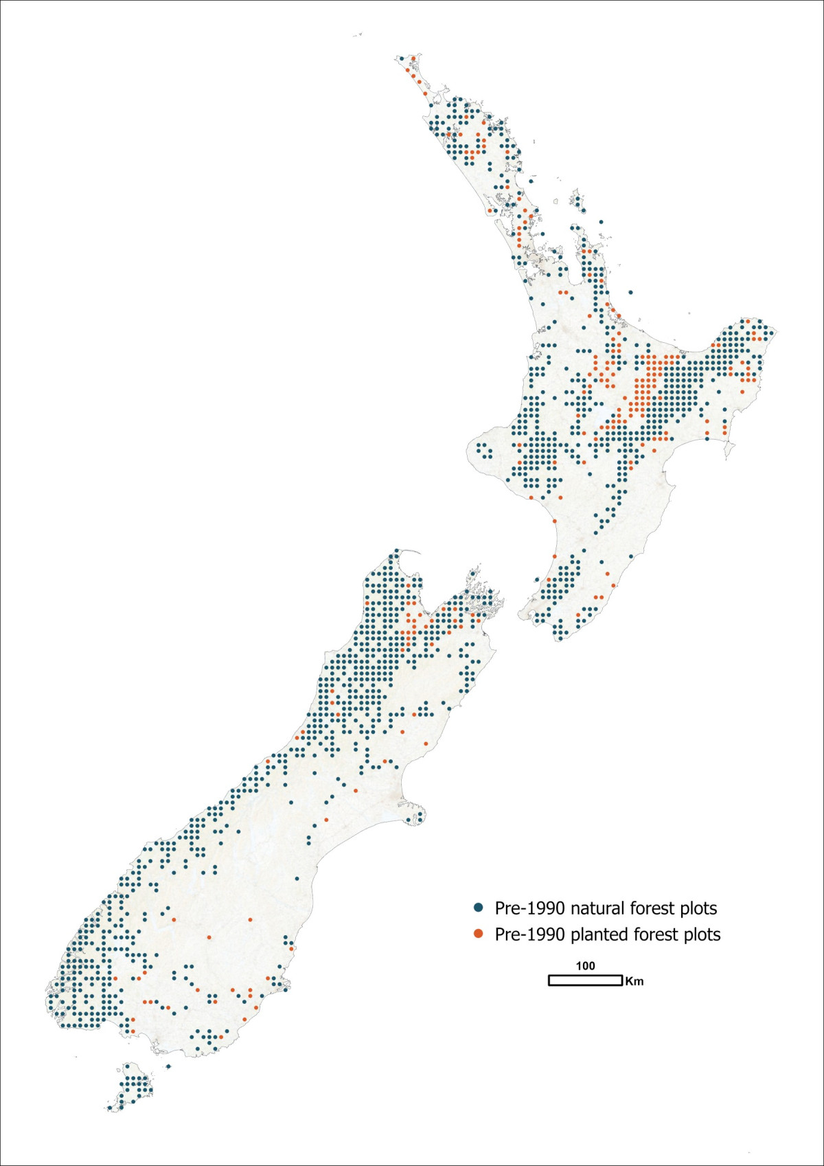
The map shows the location of pre-1990 natural forest plots and pre-1990 planted forest plots.
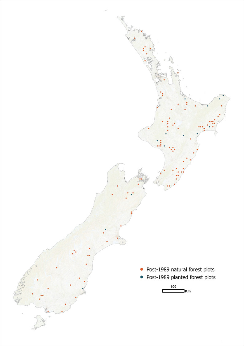
The map shows the location of post-1989 natural forest plots and post-1989 planted forest plots.

The map shows the location of post-1989 natural forest plots and post-1989 planted forest plots.
The number of hectares of each forest class in New Zealand is calculated from land use mapping. This information is used with measurements of carbon per unit of forest area to calculate the carbon stored in New Zealand forest land at a national level.
Forest data and landscape observations are collected at each site. These data are used by organisations such as the Ministry for the Environment, Department of Conservation and local government organisations for:
Guidance the Ministry for the Environment uses when measuring forest carbon.
See also Forest, soil and LiDAR data and Mapping land use.