Chapter 4: Effects on the wider environment

Land connects every part of the complex system that is te taiao, the environment. How we use land can therefore affect the many interactions between land, lakes, rivers, oceans, air, climate, and native species.
Native vegetation and wetlands continue to be removed in some regions, including the West Coast and Southland. From 1990 to 2012, 157 hectares of wetland were lost per year in Southland – mainly through conversion to pasture. Areas of native vegetation offer many benefits to farms.
More intensive agriculture and urban expansion can increase pollution in the freshwater and marine environments. This degrades the environment and has a negative influence on the native species living there. People can be affected when their drinking water is polluted and sources of wild food are contaminated.
Animals and fertiliser contribute to our greenhouse gas emissions – 53 percent of our emissions by volume in 2018 were methane and nitrous oxide, with most coming from agriculture. Emissions from livestock made up 86 percent of methane emissions.
All these impacts – loss of native vegetation, water pollution, and climate change – affect each other through feedback and cascading effects, and can cause further negative effects on the environment.
In 2018, about half (49 percent) of New Zealand was covered with native ecosystems and the other half (51 percent) with farms, pasture, and plantation (exotic) forests. (See indicators: Indigenous land cover and Exotic land cover.) In New Zealand, land covered with original or regenerating native vegetation ranges from vast areas of conservation land to small, isolated stands of regenerating bush on farms and in cities.
The area of land covered with native ecosystems continues to shrink, mainly through conversion to agriculture or forestry. (See indicator: Indigenous land cover.) Some types of native land cover are more at risk. Scrub tussocks, wetlands, and lowland forests are particularly vulnerable because they are often located in accessible areas that are suitable for agriculture and housing (see Ice, hydro, and irrigation: how water has changed the dry Mackenzie basin) (Cieraad et al., 2015).
Scrub, shrubland, and tussock grassland have seen the greatest losses in recent decades but native forest continues to be removed in some regions including the West Coast and Southland. (See indicator: Indigenous land cover.) In 2010, 10 percent of wetlands remained compared to their original extent (Ausseil et al., 2011). In Southland 157 hectares of wetland were lost per year between 1990 and 2012, mainly through conversion to pasture (Robertson et al., 2019).
Farms benefit from the presence of native vegetation. It can prevent erosion, filter nutrients out of water, and reduce the damage caused by floods – all of which increase a farm’s sustainability and ability to adapt to change (Dominati et al., 2019). Also, farmland that is used less intensively loses fewer nutrients from the soil to freshwater (PCE, 2013). Farms and landscapes that have more diverse agriculture and vegetation types receive a greater range of environmental benefits (Gómez-Creutzberg et al., 2020).
Land that is used for more intensive agriculture like dairy farming and cropping (market gardens and grain and seed growing), usually has less native vegetation and lower native biodiversity than land used for less intensive agriculture such as sheep farming (Pannell et al., 2021). Trees are often removed from intensively used land to maximise production and the reach of irrigation systems (Welsch et al., 2014).
About 25 percent of the total area of native vegetation cover in New Zealand is on land used for sheep and beef farming, compared with 1 percent of total area of native vegetation cover on land used for dairy farming (Dominati et al., 2019; Norton & Pannell, 2018). Only about 3 percent of the native vegetation on sheep and beef farms is permanently protected by covenants (Pannell et al., 2021).
Excess sediment, pollutants, and unnatural water flows cause pollution and poor ecological health in most of the rivers and lakes in catchments where the dominant land cover is urban, farming, or forestry (MfE & Stats NZ, 2020b). Nutrient and sediment run-off from land that is used intensively can cause native freshwater biodiversity to decrease (MfE & Stats NZ, 2020b).
Applying nitrogen fertiliser and animal effluent to the soil increases the risk of nitrogen moving into freshwater and its leaching into groundwater (Di & Cameron, 2002). The type of land use, soil nutrient levels and inputs, weather, and vegetation influence how increases in nitrogen applied to the land affects the amount of nitrogen in freshwater (Abell et al., 2011; Monaghan et al., 2007).
Phosphorus can accumulate in the soil when phosphorus fertiliser is applied continuously. It enters freshwater mainly when soil with high levels of phosphorus is eroded (McDowell et al., 2019). New Zealand’s large lakes and rivers have naturally low levels of phosphorus (McDowell et al., 2020b). Most of the rivers and lakes in catchments with land in the urban, pastoral, and exotic land cover classes have a higher risk of algal blooms, based on calculated nutrient concentrations (MfE & Stats NZ, 2020b).
Nitrogen and phosphorus can cause algal blooms in rivers and lakes, reducing the amount of oxygen in the water for plants and for fish to breathe. Too much nitrate-nitrogen (one form of nitrogen) in groundwater used for drinking water is also a potential human health concern (Schullehner et al., 2018). A preliminary study of nitrate contamination of drinking water in New Zealand found nitrate concentrations above potentially harmful levels in areas with high cattle density (Richards, 2021). The leaching of nitrogen and other nutrients into groundwater can take a long time. In groundwater that was dated using tracers, a sharp increase in nitrogen and other agrochemicals was observed after 1955, corresponding to the start of intensified agriculture (Morgenstern & Daughney, 2012).
Management was estimated to be effective in reducing the loss of nitrogen from pastoral land between 1995 and 2015. Methods included fencing streams, and timing irrigation and effluent to minimise run-off. However, the overall national nitrogen losses for this period increased because more land was converted to dairy farming and land use became more intensive (Monaghan et al., 2021).
Similar methods can be used to reduce the amount of phosphorus-rich soil being washed into freshwater – streams can be fenced off from livestock, and irrigation and effluent disposal adjusted so the risk of erosion is low. If these measures were taken nationally, the amounts of nitrogen, phosphorus, and sediment from pastoral land could be reduced by 34, 39, and 66 percent respectively by 2035 (McDowell et al., 2020a).
Urban and agricultural land uses produce waste, which can also pollute waterways. A large proportion of rural waste – such as scrap metal, agricultural plastics, and agrichemicals and their containers – is disposed of directly on land. This waste also risks polluting freshwater when waste blows away or when contaminants in the waste wash into freshwater or soak into groundwater (Hepburn & Keeling, 2013; Waikato Regional Council, 2014).
Pollutants from cities and towns like heavy metals from vehicles, plastic litter, and nutrients from garden fertiliser, can enter rivers, lakes, estuaries, and beaches through stormwater networks. Wastewater also pollutes waterways and coastal water with nutrients and pathogens (diseasecausing microorganisms) (MfE & Stats NZ, 2019b, 2020b).
More water is being used as New Zealand’s urban areas expand and agriculture becomes more intensive. To meet this need, a larger volume of water is taken out of rivers, lakes, and groundwater. This affects how much water is stored in aquifers, and the quantity, timing, and intensity of flows in rivers and streams. Taking water from rivers alters the volume and flow of water, which can degrade freshwater ecosystems and reduce the quality of freshwater for recreational and cultural uses (MfE & Stats NZ, 2020b).
While a small proportion (5 percent) of agricultural land is irrigated, this area is increasing especially land used for dairy farming. (See indicator: Irrigated land.) Irrigation uses large amounts of water and irrigation had the largest consented water allocation by volume (58 percent) for 2017–18. (See indicator: Consented freshwater takes.) Computer models predicted that taking water for irrigation had the greatest potential to reduce river flows across the country when compared with other uses (Booker & Henderson, 2019).
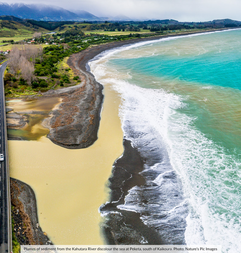
Coastal areas that receive large volumes of freshwater from rivers have correspondingly large amounts of sediment and high concentrations of nitrogen (Dudley et al., 2017; MfE & Stats NZ, 2019a, 2020b). How far these effects extend into the marine environment is not well understood.
People can become sick from contact with harmful bacteria, for example, from sewage in contaminated seawater. Kaimoana (seafood) can also be affected (MfE & Stats NZ, 2019a). From a Māori perspective, sewage systems and food gathering should occur in completely separate domains, with land-based treatment of sewage preferred (Harmsworth, 2002; MfE & Stats NZ, 2019a).
Emissions of greenhouse gases in New Zealand are contributing to global climate change. The way we use land has the largest impact on our emissions. More than half (53 percent) of our gross emissions in 2018 were methane and nitrous oxide, with most coming from agriculture. Emissions from livestock made up 86 percent of methane emissions, while 93 percent of nitrous oxide emissions came from agricultural soils (mainly due to dung and urine from livestock) (MfE & Stats NZ, 2020a).
The manufacture and transport of fertiliser in this country and overseas causes high emissions from the greenhouse gas nitrous oxide. After those from animals, fertilisers made the largest contribution to greenhouse gas emissions from New Zealand dairy farms at 15 percent of their carbon footprint. Emissions from nitrogen fertiliser were the highest across all types of fertiliser (Ledgard et al., 2011).
Greenhouse gas emissions are increasing, and in New Zealand the increase is linked to more intensive agriculture. The shift from sheep and beef farms to dairy farms increased the number of dairy cattle between 1971 and 2019, and dairy cattle emit more methane and excrete more nitrogen per animal than sheep and non-dairy cattle (MfE & Stats NZ, 2019a). (See indicator: Livestock numbers.) Urine from dairy cows that is deposited onto wet compacted soil can increase nitrous oxide emissions (van der Weerden et al., 2017).
“I woke up in darkness to the sound of a waterfall, which didn’t seem right,” says Taylah Mitchell (Te Aitanga-a-Hauiti) of that morning in October 2018. “When I stood up, my feet went into a foot of water. In the 10 minutes it took for everyone to wake up, the water had reached 1 metre. It was scary.”
A large volume of timber debris from forestry operations (slash – woody debris) in the hills behind her home had been washed downstream by heavy rain. The logs formed a dam behind Wigan Bridge, which then burst, causing flooding and damage to the bridge as well as homes.
“There was no way of getting out of our house until the water subsided because all the cars were floating. We ended up calling my dad who drove a log truck out to get us out – and he only just made it. We lost everything and our house couldn’t be repaired.”
The family has had to move into different accommodation – Taylah with a sister and her parents to another house.
“My grandparents had just moved in with us and it was really traumatising for them. Their new house is also close to a river so it took a bit of time for Nan to feel safe when it rained.
“Even talking about it now, I still find it hard to believe what happened to me. Sometimes I don’t know how to feel because my dad is in forestry. But I don’t sit here and put a lot of blame on them. It’s in the past and I’m more about how we’re going to move forward.”
Victor Walker (Te Aitanga-a-Hauiti), trustee of the Ūawanui Sustainability Project, has lived in Ūawa Tolaga Bay all his life and has seen local industries come and go. His father and many of the whānau were employed to cut and clear mānuka and kānuka for sheep farming in the steep, erosionprone hills behind the small east coast settlement.
But back in 1988, Cyclone Bola devastated the area with slips and flooding and took the lives of three local people. Concern about damage from similar events in the future led the Ūawa community to embrace forestry as a better way to use their land, despite warnings about potential issues due to the steep terrain.
“We bought into forestry as a better way to use the land than farming. For us it was an economic decision and seemed the right way to go. But 30 years later with harvesting at its peak, we are on the back foot because the mitigations to protect us and our waterways were not in place.”
A heavy rain event in 2011 brought thousands and thousands of cubic metres of forestry slash down the river. There have been several more since.
“It was terrible, really ugly. You could follow the trail of devastation from the streams to the tributaries to the main artery which is the Ūawa River, with debris and rubbish that destroyed kilometres of fences and covered most of the paddocks with silt. Some of the streams were pristine with beautiful native flora and fauna – we used to get our drinking water from them.
“We were 10 years into a 100-year environmental sustainability strategy, and we got smashed. Our vision is for a restored freshwater habitat with all the native species including fish that indicate good health. But our rivers are seriously contaminated and not in good health.
“Our coastline has also been impacted. There’s evidence that our kaimoana (seafood) like kina is relocating and in some places, becoming bitter and sour. The pāua are becoming choked because of the sediment and they’re moving to a new home away from here. As iwi, we’re concerned that we might not be able to manaaki and host manuhiri with our local foods in the way we always have.”
Massive amounts of slash ended up on the beach – it was littered with logs. Floating rafts circled the bay with the tide and were hazardous for swimmers and boaties. A hugely popular training programme at the surf lifesaving club had to be put on hold with the beach closure. As part of a clean up, there were 90 bonfires on the beach in November 2020.
“Even the fires caused some angst in the community because of the potential for smoke to drift inland. Ours is one of the greatest beaches in the world but anyone younger than eight has not been able to experience that.”
In the aftermath of the flooding, all work associated with forestry stopped. This had severe effects on the household income for many of the forestry contractors and the retailers in Ūawa. Victor acknowledges the tremendous support for the community that was shown with gifts and donations from locals as well as charities, iwi authorities, and people across the country in a time of great adversity.
“It’s really hard for the community – families like Taylah’s have lost so much. Some people want to get rid of forestry altogether while others are focussed on the benefits. There wouldn’t be one household here that isn’t touched directly or indirectly by forestry. Many of us are concerned that if we didn’t have forestry at the current level, we would be faced with higher unemployment, a proliferation of issues associated with unwellness, and the anti-social behaviour that comes with a loss of purpose, income, and positive busyness.”
For now, keeping people safe is the most important thing.
“If we see a hurricane in the South Pacific tracking our way, our Civil Defence goes on high alert and if heavy inundations of rain begin, the message to clear out goes to people near the most vulnerable streams.
“We’re looking to the Gisborne District Council and the forestry industry to assure us that in the next heavy rain we’re not going to have logs coming down our river, smashing into our bridges and houses and ending up as dangerous debris along our beaches and coast. I would have confidence for the future if they could do that in a credible way. Now, with the greatest respect, I think there’s still work to do.”
The Ūawanui Sustainability Project is a community-led initiative that aims to achieve long-term economic, environmental, and social benefits. Many agencies have contributed to and supported the project since it began in 2010.
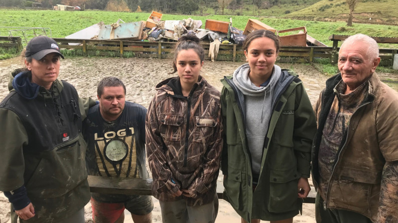
Image: Stuff
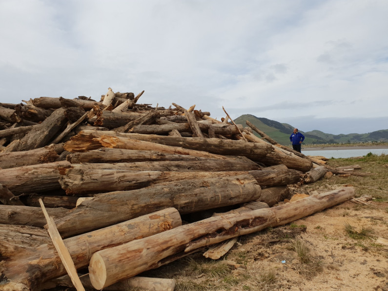
Image: Nori Parata
Chapter 4: Effects on the wider environment
April 2021
© Ministry for the Environment